You are here: Home > Network List > TA - USArray Transportable Network (new EarthScope stations) Stations List
> Station A22K Sinclair Lake, AK, USA > Earthquake Result Viewer
A22K Sinclair Lake, AK, USA - Earthquake Result Viewer

| Earthquake location: |
Taiwan |
| Earthquake latitude/longitude: |
24.5/121.9 |
| Earthquake time(UTC): |
2019/08/07 (219) 21:28:02 GMT |
| Earthquake Depth: |
10 km |
| Earthquake Magnitude: |
5.9 Mww |
| Earthquake Catalog/Contributor: |
NEIC PDE/us |
|
| Network: |
TA USArray Transportable Network (new EarthScope stations) |
| Station: |
A22K Sinclair Lake, AK, USA |
| Lat/Lon: |
71.00 N/154.97 W |
| Elevation: |
6.0 m |
|
| Distance: |
64.8 deg |
| Az: |
21.05 deg |
| Baz: |
271.973 deg |
| Ray Param: |
0.058668222 |
| Estimated Moho Depth: |
16.25 km |
| Estimated Crust Vp/Vs: |
1.60 |
| Assumed Crust Vp: |
5.782 km/s |
| Estimated Crust Vs: |
3.614 km/s |
| Estimated Crust Poisson's Ratio: |
0.18 |
|
| Radial Match: |
85.390755 % |
| Radial Bump: |
400 |
| Transverse Match: |
76.82951 % |
| Transverse Bump: |
400 |
| SOD ConfigId: |
19053131 |
| Insert Time: |
2019-08-21 21:34:07.045 +0000 |
| GWidth: |
2.5 |
| Max Bumps: |
400 |
| Tol: |
0.001 |
|
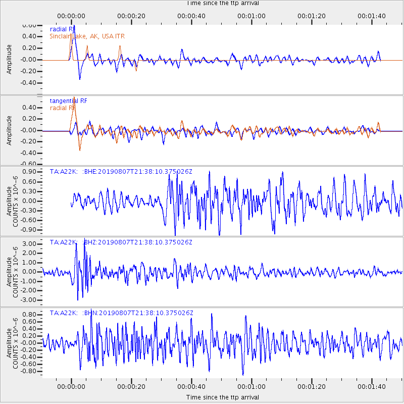
Signal To Noise
| Channel | StoN | STA | LTA |
| TA:A22K: :BHZ:20190807T21:38:10.375026Z | 7.8445115 | 1.527411E-6 | 1.9471078E-7 |
| TA:A22K: :BHN:20190807T21:38:10.375026Z | 1.8675755 | 2.5523343E-7 | 1.3666566E-7 |
| TA:A22K: :BHE:20190807T21:38:10.375026Z | 2.8583636 | 4.845802E-7 | 1.6953064E-7 |
| Arrivals |
| Ps | 1.8 SECOND |
| PpPs | 7.0 SECOND |
| PsPs/PpSs | 8.8 SECOND |


