You are here: Home > Network List > TA - USArray Transportable Network (new EarthScope stations) Stations List
> Station A09A Danville, WA, USA > Earthquake Result Viewer
A09A Danville, WA, USA - Earthquake Result Viewer
| Earthquake location: |
Near Coast Of Peru |
| Earthquake latitude/longitude: |
-13.4/-76.6 |
| Earthquake time(UTC): |
2007/08/15 (227) 23:40:57 GMT |
| Earthquake Depth: |
39 km |
| Earthquake Magnitude: |
6.7 MB, 7.9 MS, 8.0 MW, 7.5 ME |
| Earthquake Catalog/Contributor: |
WHDF/NEIC |
|
| Network: |
TA USArray Transportable Network (new EarthScope stations) |
| Station: |
A09A Danville, WA, USA |
| Lat/Lon: |
48.98 N/118.59 W |
| Elevation: |
931 m |
|
| Distance: |
72.3 deg |
| Az: |
332.447 deg |
| Baz: |
136.905 deg |
| Ray Param: |
0.053669687 |
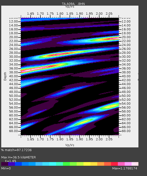
| Estimated Moho Depth: |
36.5 km |
| Estimated Crust Vp/Vs: |
1.65 |
| Assumed Crust Vp: |
6.419 km/s |
| Estimated Crust Vs: |
3.89 km/s |
| Estimated Crust Poisson's Ratio: |
0.21 |
|
| Radial Match: |
97.17236 % |
| Radial Bump: |
400 |
| Transverse Match: |
84.29065 % |
| Transverse Bump: |
400 |
| SOD ConfigId: |
2564 |
| Insert Time: |
2010-03-07 03:02:11.557 +0000 |
| GWidth: |
2.5 |
| Max Bumps: |
400 |
| Tol: |
0.001 |
|

Signal To Noise
| Channel | StoN | STA | LTA |
| TA:A09A: :BHN:20070815T23:51:48.65001Z | 21.214647 | 1.1569934E-6 | 5.453748E-8 |
| TA:A09A: :BHE:20070815T23:51:48.65001Z | 10.85203 | 9.661399E-7 | 8.90285E-8 |
| TA:A09A: :BHZ:20070815T23:51:48.65001Z | 36.558926 | 3.536837E-6 | 9.674346E-8 |
| Arrivals |
| Ps | 3.8 SECOND |
| PpPs | 15 SECOND |
| PsPs/PpSs | 18 SECOND |


