You are here: Home > Network List > TA - USArray Transportable Network (new EarthScope stations) Stations List
> Station D23K Nanushuk River, AK USA > Earthquake Result Viewer
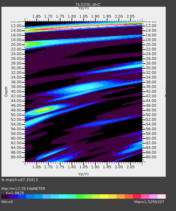
D23K Nanushuk River, AK USA - Earthquake Result Viewer
| Earthquake location: |
Taiwan |
| Earthquake latitude/longitude: |
24.5/121.9 |
| Earthquake time(UTC): |
2019/08/07 (219) 21:28:02 GMT |
| Earthquake Depth: |
10 km |
| Earthquake Magnitude: |
5.9 Mww |
| Earthquake Catalog/Contributor: |
NEIC PDE/us |
|
| Network: |
TA USArray Transportable Network (new EarthScope stations) |
| Station: |
D23K Nanushuk River, AK USA |
| Lat/Lon: |
68.97 N/150.68 W |
| Elevation: |
406 m |
|
| Distance: |
66.5 deg |
| Az: |
23.164 deg |
| Baz: |
276.877 deg |
| Ray Param: |
0.05759797 |
| Estimated Moho Depth: |
12.25 km |
| Estimated Crust Vp/Vs: |
1.86 |
| Assumed Crust Vp: |
6.221 km/s |
| Estimated Crust Vs: |
3.34 km/s |
| Estimated Crust Poisson's Ratio: |
0.30 |
|
| Radial Match: |
87.33413 % |
| Radial Bump: |
400 |
| Transverse Match: |
79.03562 % |
| Transverse Bump: |
400 |
| SOD ConfigId: |
19053131 |
| Insert Time: |
2019-08-21 21:34:16.908 +0000 |
| GWidth: |
2.5 |
| Max Bumps: |
400 |
| Tol: |
0.001 |
|

Signal To Noise
| Channel | StoN | STA | LTA |
| TA:D23K: :BHZ:20190807T21:38:20.89999Z | 14.433416 | 1.0529743E-6 | 7.295392E-8 |
| TA:D23K: :BHN:20190807T21:38:20.89999Z | 3.3143187 | 1.3303877E-7 | 4.014061E-8 |
| TA:D23K: :BHE:20190807T21:38:20.89999Z | 10.128785 | 3.926437E-7 | 3.876513E-8 |
| Arrivals |
| Ps | 1.8 SECOND |
| PpPs | 5.4 SECOND |
| PsPs/PpSs | 7.2 SECOND |


