You are here: Home > Network List > TA - USArray Transportable Network (new EarthScope stations) Stations List
> Station E19K Redstone River, AK, USA > Earthquake Result Viewer
E19K Redstone River, AK, USA - Earthquake Result Viewer
| Earthquake location: |
Taiwan |
| Earthquake latitude/longitude: |
24.5/121.9 |
| Earthquake time(UTC): |
2019/08/07 (219) 21:28:02 GMT |
| Earthquake Depth: |
10 km |
| Earthquake Magnitude: |
5.9 Mww |
| Earthquake Catalog/Contributor: |
NEIC PDE/us |
|
| Network: |
TA USArray Transportable Network (new EarthScope stations) |
| Station: |
E19K Redstone River, AK, USA |
| Lat/Lon: |
67.46 N/157.23 W |
| Elevation: |
441 m |
|
| Distance: |
64.1 deg |
| Az: |
25.024 deg |
| Baz: |
271.576 deg |
| Ray Param: |
0.05911576 |
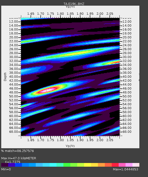
| Estimated Moho Depth: |
47.0 km |
| Estimated Crust Vp/Vs: |
1.73 |
| Assumed Crust Vp: |
6.577 km/s |
| Estimated Crust Vs: |
3.807 km/s |
| Estimated Crust Poisson's Ratio: |
0.25 |
|
| Radial Match: |
86.257576 % |
| Radial Bump: |
400 |
| Transverse Match: |
85.8189 % |
| Transverse Bump: |
400 |
| SOD ConfigId: |
19053131 |
| Insert Time: |
2019-08-21 21:34:21.154 +0000 |
| GWidth: |
2.5 |
| Max Bumps: |
400 |
| Tol: |
0.001 |
|

Signal To Noise
| Channel | StoN | STA | LTA |
| TA:E19K: :BHZ:20190807T21:38:05.850002Z | 12.527594 | 6.2962056E-7 | 5.02587E-8 |
| TA:E19K: :BHN:20190807T21:38:05.850002Z | 6.3139367 | 1.9577652E-7 | 3.1007044E-8 |
| TA:E19K: :BHE:20190807T21:38:05.850002Z | 8.501148 | 2.7297008E-7 | 3.2109792E-8 |
| Arrivals |
| Ps | 5.4 SECOND |
| PpPs | 19 SECOND |
| PsPs/PpSs | 24 SECOND |


