You are here: Home > Network List > TA - USArray Transportable Network (new EarthScope stations) Stations List
> Station F20K Avaraart Lake, AK, USA > Earthquake Result Viewer
F20K Avaraart Lake, AK, USA - Earthquake Result Viewer
| Earthquake location: |
Taiwan |
| Earthquake latitude/longitude: |
24.5/121.9 |
| Earthquake time(UTC): |
2019/08/07 (219) 21:28:02 GMT |
| Earthquake Depth: |
10 km |
| Earthquake Magnitude: |
5.9 Mww |
| Earthquake Catalog/Contributor: |
NEIC PDE/us |
|
| Network: |
TA USArray Transportable Network (new EarthScope stations) |
| Station: |
F20K Avaraart Lake, AK, USA |
| Lat/Lon: |
67.05 N/155.73 W |
| Elevation: |
136 m |
|
| Distance: |
64.7 deg |
| Az: |
25.452 deg |
| Baz: |
273.148 deg |
| Ray Param: |
0.058727503 |
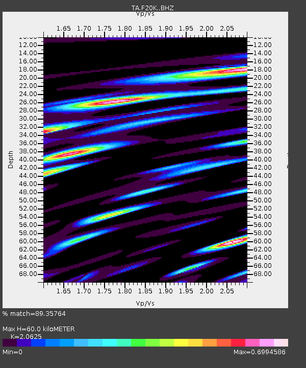
| Estimated Moho Depth: |
60.0 km |
| Estimated Crust Vp/Vs: |
2.06 |
| Assumed Crust Vp: |
6.522 km/s |
| Estimated Crust Vs: |
3.162 km/s |
| Estimated Crust Poisson's Ratio: |
0.35 |
|
| Radial Match: |
89.35764 % |
| Radial Bump: |
400 |
| Transverse Match: |
80.00916 % |
| Transverse Bump: |
400 |
| SOD ConfigId: |
19053131 |
| Insert Time: |
2019-08-21 21:34:29.636 +0000 |
| GWidth: |
2.5 |
| Max Bumps: |
400 |
| Tol: |
0.001 |
|
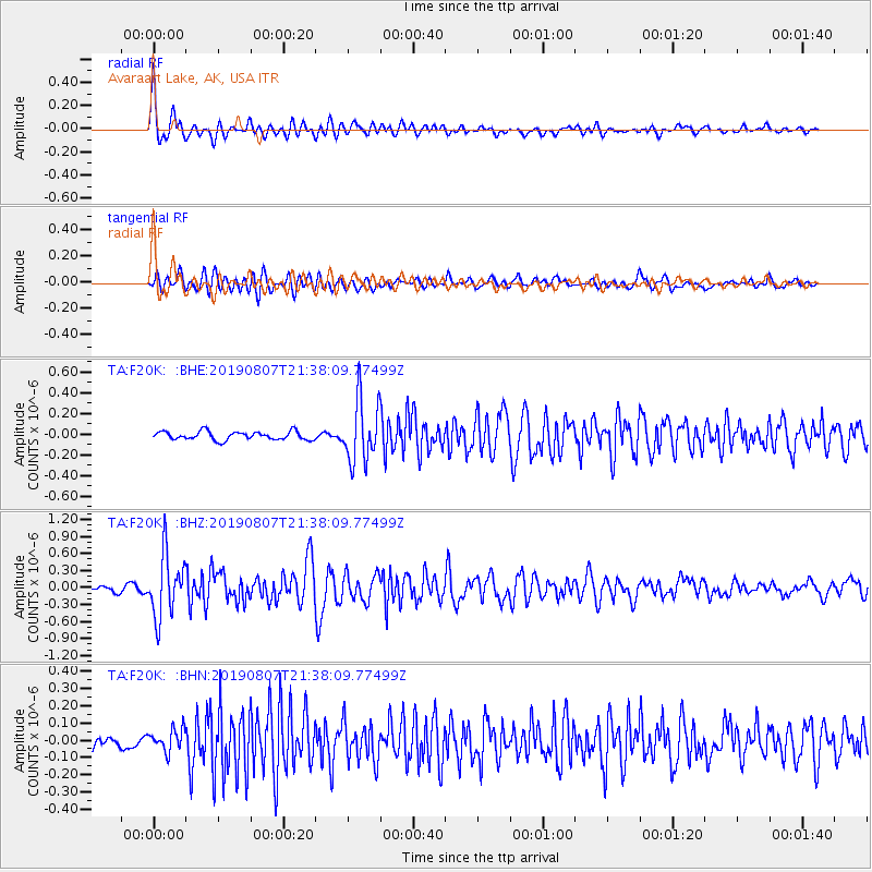
Signal To Noise
| Channel | StoN | STA | LTA |
| TA:F20K: :BHZ:20190807T21:38:09.77499Z | 11.953313 | 5.446193E-7 | 4.5562206E-8 |
| TA:F20K: :BHN:20190807T21:38:09.77499Z | 2.1299434 | 6.452273E-8 | 3.029317E-8 |
| TA:F20K: :BHE:20190807T21:38:09.77499Z | 7.3140645 | 2.9791232E-7 | 4.0731432E-8 |
| Arrivals |
| Ps | 10 SECOND |
| PpPs | 27 SECOND |
| PsPs/PpSs | 37 SECOND |


