You are here: Home > Network List > TA - USArray Transportable Network (new EarthScope stations) Stations List
> Station A09A Danville, WA, USA > Earthquake Result Viewer
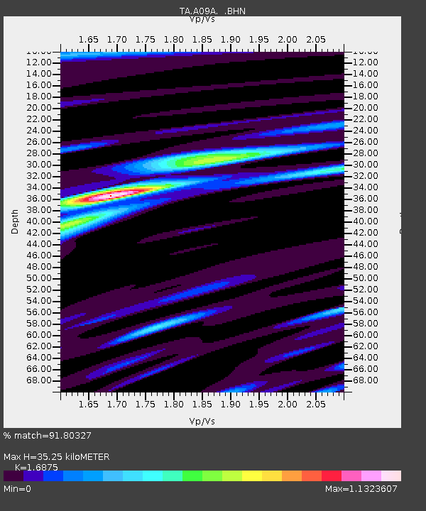
A09A Danville, WA, USA - Earthquake Result Viewer
| Earthquake location: |
Kamchatka Peninsula, Russia |
| Earthquake latitude/longitude: |
52.1/157.3 |
| Earthquake time(UTC): |
2007/05/30 (150) 20:22:12 GMT |
| Earthquake Depth: |
116 km |
| Earthquake Magnitude: |
6.4 MB, 6.4 MW, 6.4 MW |
| Earthquake Catalog/Contributor: |
WHDF/NEIC |
|
| Network: |
TA USArray Transportable Network (new EarthScope stations) |
| Station: |
A09A Danville, WA, USA |
| Lat/Lon: |
48.98 N/118.59 W |
| Elevation: |
931 m |
|
| Distance: |
50.7 deg |
| Az: |
57.941 deg |
| Baz: |
307.555 deg |
| Ray Param: |
0.067533486 |
| Estimated Moho Depth: |
35.25 km |
| Estimated Crust Vp/Vs: |
1.69 |
| Assumed Crust Vp: |
6.419 km/s |
| Estimated Crust Vs: |
3.804 km/s |
| Estimated Crust Poisson's Ratio: |
0.23 |
|
| Radial Match: |
91.80327 % |
| Radial Bump: |
400 |
| Transverse Match: |
90.879036 % |
| Transverse Bump: |
400 |
| SOD ConfigId: |
2564 |
| Insert Time: |
2010-03-07 03:02:25.724 +0000 |
| GWidth: |
2.5 |
| Max Bumps: |
400 |
| Tol: |
0.001 |
|

Signal To Noise
| Channel | StoN | STA | LTA |
| TA:A09A: :BHN:20070530T20:30:29.550015Z | 17.616745 | 1.6864141E-6 | 9.5727906E-8 |
| TA:A09A: :BHE:20070530T20:30:29.550015Z | 38.82198 | 2.205306E-6 | 5.6805604E-8 |
| TA:A09A: :BHZ:20070530T20:30:29.550015Z | 66.73487 | 5.1836523E-6 | 7.7675324E-8 |
| Arrivals |
| Ps | 4.0 SECOND |
| PpPs | 14 SECOND |
| PsPs/PpSs | 18 SECOND |


