You are here: Home > Network List > TA - USArray Transportable Network (new EarthScope stations) Stations List
> Station J18K Innoko River, AK, USA > Earthquake Result Viewer
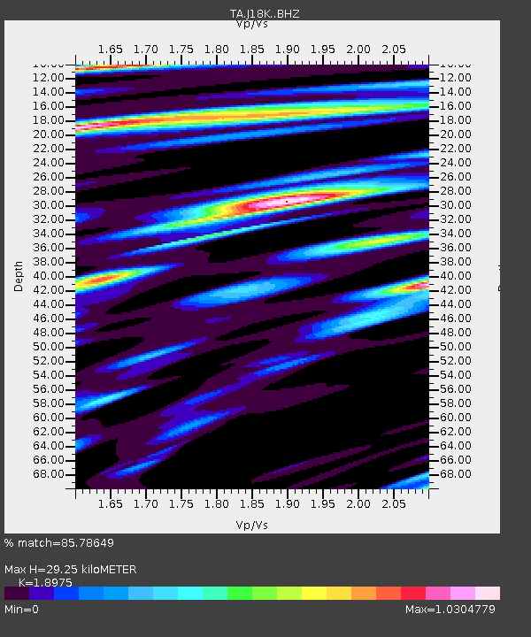
J18K Innoko River, AK, USA - Earthquake Result Viewer
| Earthquake location: |
Taiwan |
| Earthquake latitude/longitude: |
24.5/121.9 |
| Earthquake time(UTC): |
2019/08/07 (219) 21:28:02 GMT |
| Earthquake Depth: |
10 km |
| Earthquake Magnitude: |
5.9 Mww |
| Earthquake Catalog/Contributor: |
NEIC PDE/us |
|
| Network: |
TA USArray Transportable Network (new EarthScope stations) |
| Station: |
J18K Innoko River, AK, USA |
| Lat/Lon: |
63.47 N/156.72 W |
| Elevation: |
506 m |
|
| Distance: |
64.5 deg |
| Az: |
29.456 deg |
| Baz: |
273.965 deg |
| Ray Param: |
0.058850955 |
| Estimated Moho Depth: |
29.25 km |
| Estimated Crust Vp/Vs: |
1.90 |
| Assumed Crust Vp: |
6.182 km/s |
| Estimated Crust Vs: |
3.258 km/s |
| Estimated Crust Poisson's Ratio: |
0.31 |
|
| Radial Match: |
85.78649 % |
| Radial Bump: |
400 |
| Transverse Match: |
61.760754 % |
| Transverse Bump: |
400 |
| SOD ConfigId: |
19053131 |
| Insert Time: |
2019-08-21 21:34:56.955 +0000 |
| GWidth: |
2.5 |
| Max Bumps: |
400 |
| Tol: |
0.001 |
|

Signal To Noise
| Channel | StoN | STA | LTA |
| TA:J18K: :BHZ:20190807T21:38:08.52499Z | 9.208383 | 4.291404E-7 | 4.6603233E-8 |
| TA:J18K: :BHN:20190807T21:38:08.52499Z | 1.9236662 | 6.841362E-8 | 3.556418E-8 |
| TA:J18K: :BHE:20190807T21:38:08.52499Z | 4.6536894 | 1.6973205E-7 | 3.6472578E-8 |
| Arrivals |
| Ps | 4.4 SECOND |
| PpPs | 13 SECOND |
| PsPs/PpSs | 18 SECOND |


