You are here: Home > Network List > TA - USArray Transportable Network (new EarthScope stations) Stations List
> Station A09A Danville, WA, USA > Earthquake Result Viewer
A09A Danville, WA, USA - Earthquake Result Viewer
| Earthquake location: |
Near Coast Of Guatemala |
| Earthquake latitude/longitude: |
13.6/-90.6 |
| Earthquake time(UTC): |
2008/04/15 (106) 03:03:04 GMT |
| Earthquake Depth: |
33 km |
| Earthquake Magnitude: |
5.6 MB, 5.8 MS, 6.1 MW, 6.1 MW |
| Earthquake Catalog/Contributor: |
WHDF/NEIC |
|
| Network: |
TA USArray Transportable Network (new EarthScope stations) |
| Station: |
A09A Danville, WA, USA |
| Lat/Lon: |
48.98 N/118.59 W |
| Elevation: |
931 m |
|
| Distance: |
42.2 deg |
| Az: |
332.578 deg |
| Baz: |
137.179 deg |
| Ray Param: |
0.07326625 |
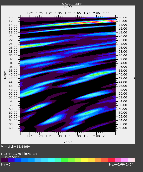
| Estimated Moho Depth: |
11.75 km |
| Estimated Crust Vp/Vs: |
2.08 |
| Assumed Crust Vp: |
6.419 km/s |
| Estimated Crust Vs: |
3.082 km/s |
| Estimated Crust Poisson's Ratio: |
0.35 |
|
| Radial Match: |
83.84694 % |
| Radial Bump: |
400 |
| Transverse Match: |
66.53725 % |
| Transverse Bump: |
400 |
| SOD ConfigId: |
2504 |
| Insert Time: |
2010-03-07 03:02:46.794 +0000 |
| GWidth: |
2.5 |
| Max Bumps: |
400 |
| Tol: |
0.001 |
|

Signal To Noise
| Channel | StoN | STA | LTA |
| TA:A09A: :BHN:20080415T03:10:23.649014Z | 5.109612 | 8.731514E-7 | 1.7088409E-7 |
| TA:A09A: :BHE:20080415T03:10:23.649014Z | 3.2012532 | 4.899471E-7 | 1.5304855E-7 |
| TA:A09A: :BHZ:20080415T03:10:23.649014Z | 3.9378567 | 2.7909186E-7 | 7.087405E-8 |
| Arrivals |
| Ps | 2.1 SECOND |
| PpPs | 5.3 SECOND |
| PsPs/PpSs | 7.4 SECOND |


