You are here: Home > Network List > IW - Intermountain West Stations List
> Station MOOW Moose Ponds, Wyoming, USA > Earthquake Result Viewer
MOOW Moose Ponds, Wyoming, USA - Earthquake Result Viewer
*The percent match for this event was below the threshold and hence no stack was calculated.
| Earthquake location: |
Northern Peru |
| Earthquake latitude/longitude: |
-4.9/-76.3 |
| Earthquake time(UTC): |
2017/01/02 (002) 13:13:48 GMT |
| Earthquake Depth: |
108 km |
| Earthquake Magnitude: |
5.9 Mwb |
| Earthquake Catalog/Contributor: |
NEIC PDE/us |
|
| Network: |
IW Intermountain West |
| Station: |
MOOW Moose Ponds, Wyoming, USA |
| Lat/Lon: |
43.75 N/110.74 W |
| Elevation: |
2128 m |
|
| Distance: |
57.5 deg |
| Az: |
330.951 deg |
| Baz: |
138.117 deg |
| Ray Param: |
$rayparam |
*The percent match for this event was below the threshold and hence was not used in the summary stack. |
|
| Radial Match: |
66.62806 % |
| Radial Bump: |
400 |
| Transverse Match: |
45.727543 % |
| Transverse Bump: |
397 |
| SOD ConfigId: |
1943534 |
| Insert Time: |
2017-01-16 13:16:31.912 +0000 |
| GWidth: |
2.5 |
| Max Bumps: |
400 |
| Tol: |
0.001 |
|
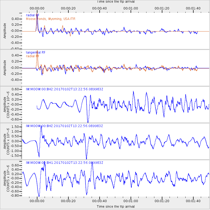
Signal To Noise
| Channel | StoN | STA | LTA |
| IW:MOOW:00:BHZ:20170102T13:22:56.089983Z | 4.0518174 | 8.565481E-7 | 2.113985E-7 |
| IW:MOOW:00:BH1:20170102T13:22:56.089983Z | 3.8573136 | 5.035115E-7 | 1.3053423E-7 |
| IW:MOOW:00:BH2:20170102T13:22:56.089983Z | 3.558408 | 3.651959E-7 | 1.02629E-7 |
| Arrivals |
| Ps | |
| PpPs | |
| PsPs/PpSs | |


