You are here: Home > Network List > TA - USArray Transportable Network (new EarthScope stations) Stations List
> Station B11A Sanpoint, ID, USA > Earthquake Result Viewer
B11A Sanpoint, ID, USA - Earthquake Result Viewer
| Earthquake location: |
South Of Fiji Islands |
| Earthquake latitude/longitude: |
-26.0/-177.5 |
| Earthquake time(UTC): |
2007/12/09 (343) 07:28:20 GMT |
| Earthquake Depth: |
152 km |
| Earthquake Magnitude: |
7.0 MB, 7.8 MW, 7.7 MW |
| Earthquake Catalog/Contributor: |
WHDF/NEIC |
|
| Network: |
TA USArray Transportable Network (new EarthScope stations) |
| Station: |
B11A Sanpoint, ID, USA |
| Lat/Lon: |
48.44 N/116.37 W |
| Elevation: |
870 m |
|
| Distance: |
92.1 deg |
| Az: |
35.707 deg |
| Baz: |
232.07 deg |
| Ray Param: |
0.04144436 |
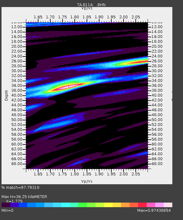
| Estimated Moho Depth: |
36.25 km |
| Estimated Crust Vp/Vs: |
1.77 |
| Assumed Crust Vp: |
6.571 km/s |
| Estimated Crust Vs: |
3.702 km/s |
| Estimated Crust Poisson's Ratio: |
0.27 |
|
| Radial Match: |
97.79318 % |
| Radial Bump: |
260 |
| Transverse Match: |
81.844696 % |
| Transverse Bump: |
400 |
| SOD ConfigId: |
2564 |
| Insert Time: |
2010-03-07 03:03:26.871 +0000 |
| GWidth: |
2.5 |
| Max Bumps: |
400 |
| Tol: |
0.001 |
|
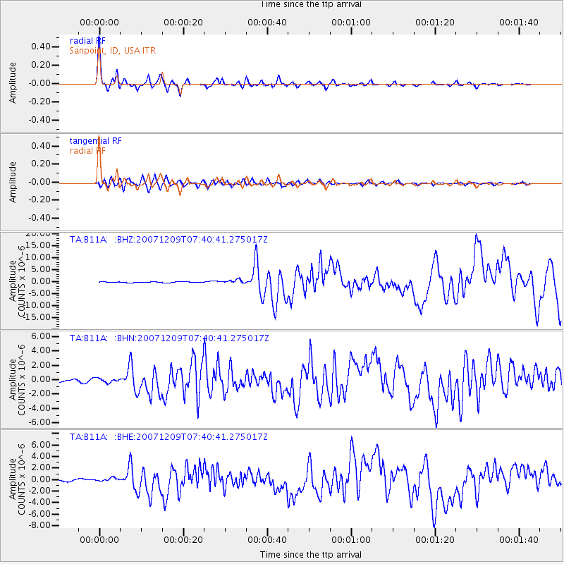
Signal To Noise
| Channel | StoN | STA | LTA |
| TA:B11A: :BHN:20071209T07:40:41.275017Z | 2.4208992 | 2.8967736E-7 | 1.1965693E-7 |
| TA:B11A: :BHE:20071209T07:40:41.275017Z | 1.9477953 | 3.0150065E-7 | 1.5479073E-7 |
| TA:B11A: :BHZ:20071209T07:40:41.275017Z | 4.422929 | 7.12046E-7 | 1.609897E-7 |
| Arrivals |
| Ps | 4.4 SECOND |
| PpPs | 15 SECOND |
| PsPs/PpSs | 19 SECOND |


