You are here: Home > Network List > TA - USArray Transportable Network (new EarthScope stations) Stations List
> Station B11A Sanpoint, ID, USA > Earthquake Result Viewer
B11A Sanpoint, ID, USA - Earthquake Result Viewer
| Earthquake location: |
Near Coast Of Peru |
| Earthquake latitude/longitude: |
-13.4/-76.6 |
| Earthquake time(UTC): |
2007/08/15 (227) 23:40:57 GMT |
| Earthquake Depth: |
39 km |
| Earthquake Magnitude: |
6.7 MB, 7.9 MS, 8.0 MW, 7.5 ME |
| Earthquake Catalog/Contributor: |
WHDF/NEIC |
|
| Network: |
TA USArray Transportable Network (new EarthScope stations) |
| Station: |
B11A Sanpoint, ID, USA |
| Lat/Lon: |
48.44 N/116.37 W |
| Elevation: |
870 m |
|
| Distance: |
70.9 deg |
| Az: |
333.214 deg |
| Baz: |
138.808 deg |
| Ray Param: |
0.054583896 |
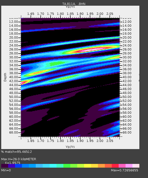
| Estimated Moho Depth: |
26.0 km |
| Estimated Crust Vp/Vs: |
1.96 |
| Assumed Crust Vp: |
6.571 km/s |
| Estimated Crust Vs: |
3.357 km/s |
| Estimated Crust Poisson's Ratio: |
0.32 |
|
| Radial Match: |
95.46512 % |
| Radial Bump: |
311 |
| Transverse Match: |
87.95637 % |
| Transverse Bump: |
400 |
| SOD ConfigId: |
2564 |
| Insert Time: |
2010-03-07 03:03:48.668 +0000 |
| GWidth: |
2.5 |
| Max Bumps: |
400 |
| Tol: |
0.001 |
|
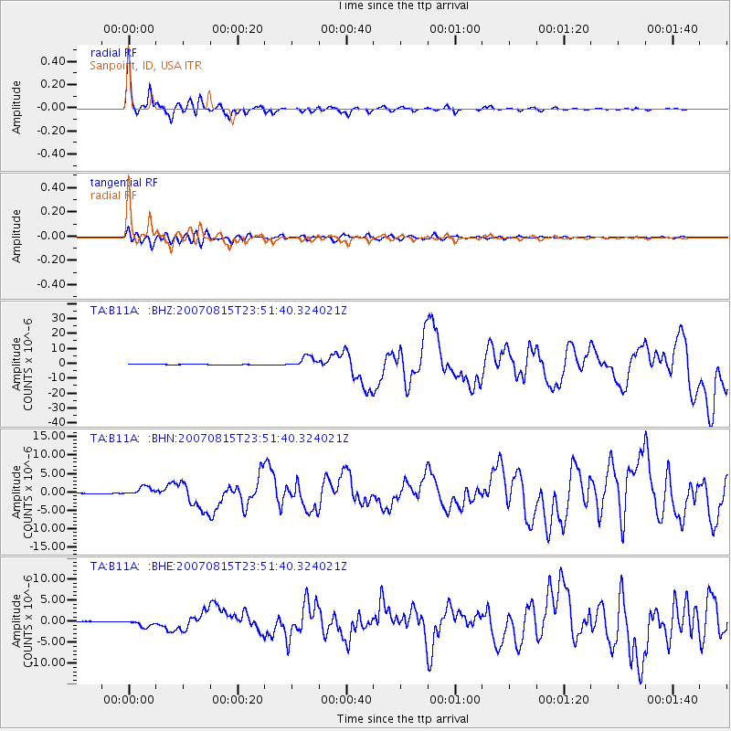
Signal To Noise
| Channel | StoN | STA | LTA |
| TA:B11A: :BHN:20070815T23:51:40.324021Z | 16.677042 | 1.2322308E-6 | 7.3887854E-8 |
| TA:B11A: :BHE:20070815T23:51:40.324021Z | 15.405037 | 8.45328E-7 | 5.487348E-8 |
| TA:B11A: :BHZ:20070815T23:51:40.324021Z | 23.631155 | 3.68002E-6 | 1.5572748E-7 |
| Arrivals |
| Ps | 3.9 SECOND |
| PpPs | 11 SECOND |
| PsPs/PpSs | 15 SECOND |


