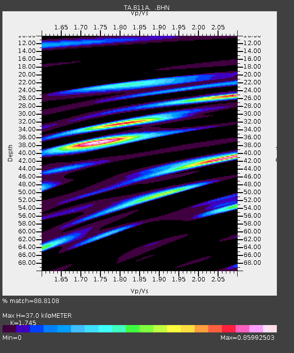
B11A Sanpoint, ID, USA - Earthquake Result Viewer
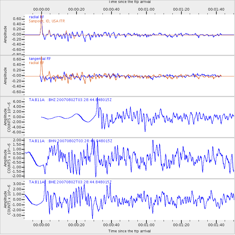
Earthquake location: Andreanof Islands, Aleutian Is.
Earthquake latitude/longitude: 51.3/-180.0
Earthquake time(UTC): 2007/08/02 (214) 03:21:42 GMT
Earthquake Depth: 21 km
Earthquake Magnitude: 6.3 MB, 6.6 MS, 6.7 MW, 6.6 MW
Earthquake Catalog/Contributor: WHDF/NEIC
Network: TA USArray Transportable Network (new EarthScope stations)
Station: B11A Sanpoint, ID, USA
Lat/Lon: 48.44 N/116.37 W
Elevation: 870 m
Distance: 40.0 deg
Az: 68.265 deg
Baz: 298.887 deg
Ray Param: 0.07464929
Estimated Moho Depth: 37.0 km
Estimated Crust Vp/Vs: 1.75
Assumed Crust Vp: 6.571 km/s
Estimated Crust Vs: 3.765 km/s
Estimated Crust Poisson's Ratio: 0.26
Radial Match: 88.8108 %
Radial Bump: 400
Transverse Match: 71.09967 %
Transverse Bump: 400
SOD ConfigId: 2564
Insert Time: 2010-03-07 03:03:50.307 +0000
GWidth: 2.5
Max Bumps: 400
Tol: 0.001

Signal To Noise

ChannelStoNSTALTA
TA:B11A: :BHN:20070802T03:28:44.848015Z2.73540339.5016134E-73.4735694E-7
TA:B11A: :BHE:20070802T03:28:44.848015Z2.20021721.4891872E-66.7683646E-7
TA:B11A: :BHZ:20070802T03:28:44.848015Z5.1688743.0842175E-65.966904E-7
Arrivals
Ps4.5 SECOND
PpPs14 SECOND
PsPs/PpSs19 SECOND