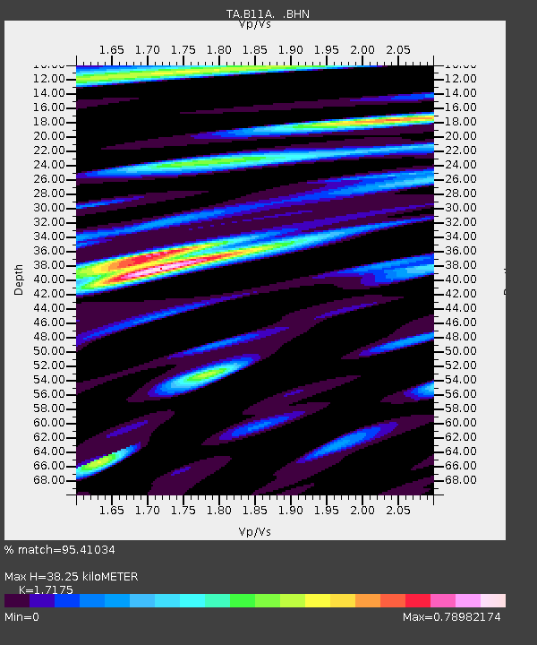
B11A Sanpoint, ID, USA - Earthquake Result Viewer
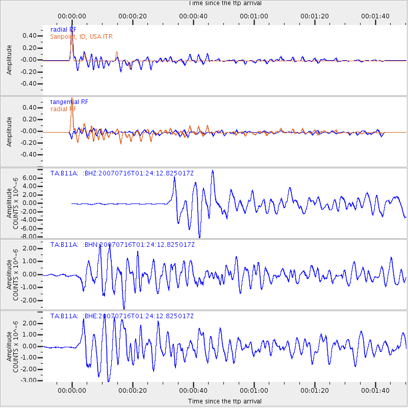
Earthquake location: Near West Coast Of Honshu, Japan
Earthquake latitude/longitude: 37.5/138.4
Earthquake time(UTC): 2007/07/16 (197) 01:13:22 GMT
Earthquake Depth: 12 km
Earthquake Magnitude: 6.5 MB, 6.4 MS, 6.6 MW, 6.5 MW
Earthquake Catalog/Contributor: WHDF/NEIC
Network: TA USArray Transportable Network (new EarthScope stations)
Station: B11A Sanpoint, ID, USA
Lat/Lon: 48.44 N/116.37 W
Elevation: 870 m
Distance: 71.7 deg
Az: 42.602 deg
Baz: 306.096 deg
Ray Param: 0.05414541
Estimated Moho Depth: 38.25 km
Estimated Crust Vp/Vs: 1.72
Assumed Crust Vp: 6.571 km/s
Estimated Crust Vs: 3.826 km/s
Estimated Crust Poisson's Ratio: 0.24
Radial Match: 95.41034 %
Radial Bump: 400
Transverse Match: 79.179375 %
Transverse Bump: 400
SOD ConfigId: 2564
Insert Time: 2010-03-07 03:04:00.277 +0000
GWidth: 2.5
Max Bumps: 400
Tol: 0.001

Signal To Noise

ChannelStoNSTALTA
TA:B11A: :BHN:20070716T01:24:12.825017Z10.8520374.383568E-74.0393964E-8
TA:B11A: :BHE:20070716T01:24:12.825017Z18.640188.547408E-74.5854748E-8
TA:B11A: :BHZ:20070716T01:24:12.825017Z30.3424452.2686495E-67.476818E-8
Arrivals
Ps4.3 SECOND
PpPs15 SECOND
PsPs/PpSs20 SECOND