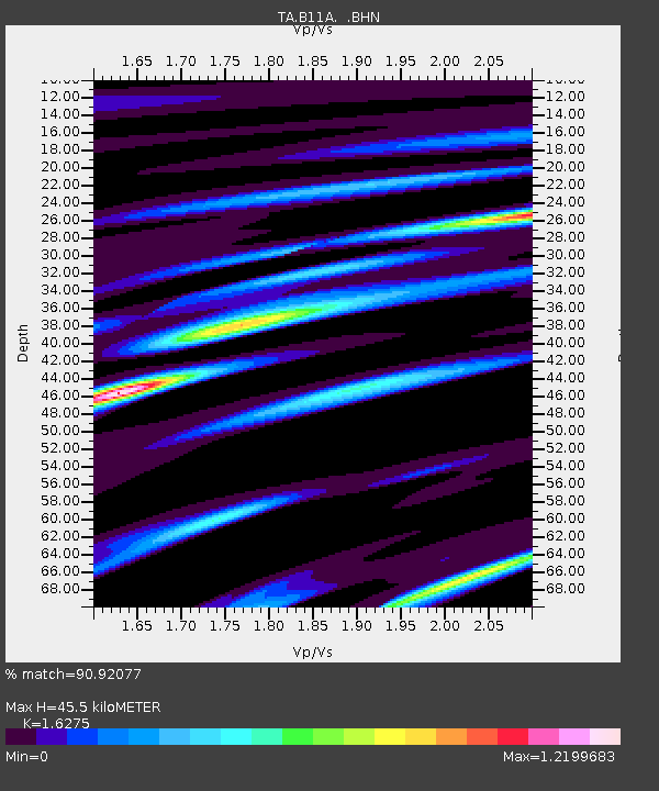
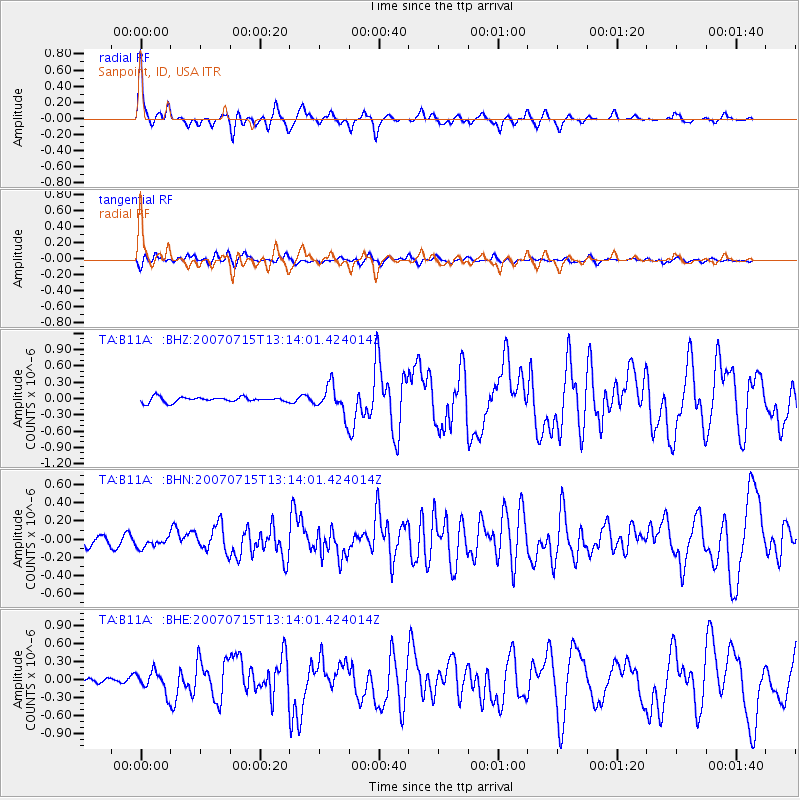
B11A Sanpoint, ID, USA - Earthquake Result Viewer

Earthquake location: Fox Islands, Aleutian Islands
Earthquake latitude/longitude: 52.5/-168.0
Earthquake time(UTC): 2007/07/15 (196) 13:08:00 GMT
Earthquake Depth: 10 km
Earthquake Magnitude: 5.8 MB, 5.9 MS, 6.1 MW, 6.0 MW
Earthquake Catalog/Contributor: WHDF/NEIC
Network: TA USArray Transportable Network (new EarthScope stations)
Station: B11A Sanpoint, ID, USA
Lat/Lon: 48.44 N/116.37 W
Elevation: 870 m
Distance: 32.6 deg
Az: 76.07 deg
Baz: 296.947 deg
Ray Param: 0.07859647
Estimated Moho Depth: 45.5 km
Estimated Crust Vp/Vs: 1.63
Assumed Crust Vp: 6.571 km/s
Estimated Crust Vs: 4.037 km/s
Estimated Crust Poisson's Ratio: 0.20
Radial Match: 90.92077 %
Radial Bump: 325
Transverse Match: 72.14626 %
Transverse Bump: 400
SOD ConfigId: 2564
Insert Time: 2010-03-07 03:04:03.172 +0000
GWidth: 2.5
Max Bumps: 400
Tol: 0.001

Signal To Noise

ChannelStoNSTALTA
TA:B11A: :BHN:20070715T13:14:01.424014Z1.22446846.584154E-85.3771533E-8
TA:B11A: :BHE:20070715T13:14:01.424014Z4.2207691.7140387E-74.060963E-8
TA:B11A: :BHZ:20070715T13:14:01.424014Z5.52088262.583809E-74.6800647E-8
Arrivals
Ps4.8 SECOND
PpPs17 SECOND
PsPs/PpSs21 SECOND