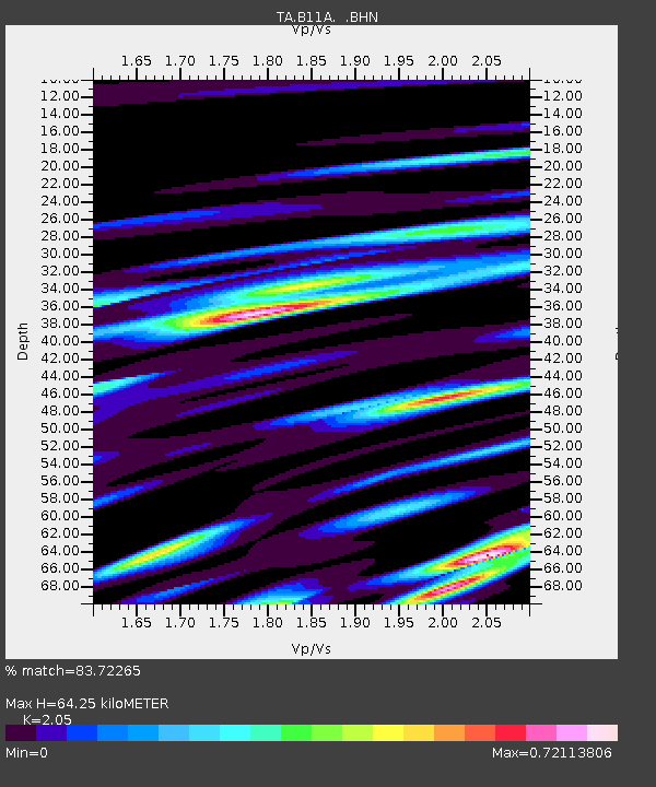
B11A Sanpoint, ID, USA - Earthquake Result Viewer
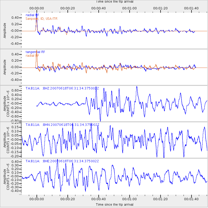
Earthquake location: New Ireland Region, P.N.G.
Earthquake latitude/longitude: -3.6/151.0
Earthquake time(UTC): 2007/06/18 (169) 06:18:48 GMT
Earthquake Depth: 26 km
Earthquake Magnitude: 5.7 MB, 6.2 MS, 6.3 MW, 6.1 MW
Earthquake Catalog/Contributor: WHDF/NEIC
Network: TA USArray Transportable Network (new EarthScope stations)
Station: B11A Sanpoint, ID, USA
Lat/Lon: 48.44 N/116.37 W
Elevation: 870 m
Distance: 94.4 deg
Az: 41.851 deg
Baz: 269.636 deg
Ray Param: 0.04103787
Estimated Moho Depth: 64.25 km
Estimated Crust Vp/Vs: 2.05
Assumed Crust Vp: 6.571 km/s
Estimated Crust Vs: 3.205 km/s
Estimated Crust Poisson's Ratio: 0.34
Radial Match: 83.72265 %
Radial Bump: 400
Transverse Match: 57.909023 %
Transverse Bump: 400
SOD ConfigId: 2564
Insert Time: 2010-03-07 03:04:13.491 +0000
GWidth: 2.5
Max Bumps: 400
Tol: 0.001

Signal To Noise

ChannelStoNSTALTA
TA:B11A: :BHN:20070618T06:31:34.375002Z1.72288681.1569725E-76.715313E-8
TA:B11A: :BHE:20070618T06:31:34.375002Z2.15118811.283529E-75.966605E-8
TA:B11A: :BHZ:20070618T06:31:34.375002Z4.81740432.006721E-74.1655646E-8
Arrivals
Ps10 SECOND
PpPs29 SECOND
PsPs/PpSs40 SECOND