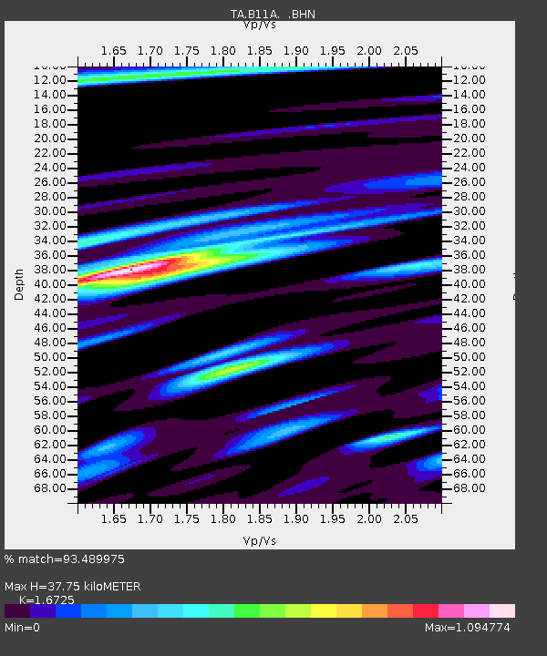
B11A Sanpoint, ID, USA - Earthquake Result Viewer
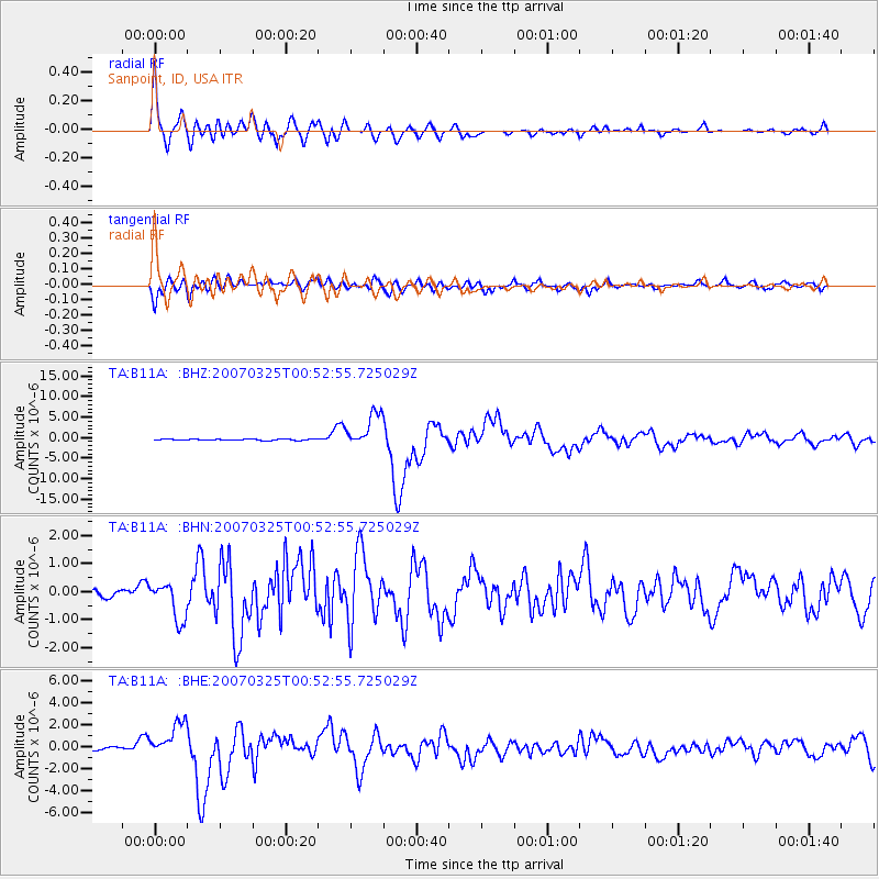
Earthquake location: Near West Coast Of Honshu, Japan
Earthquake latitude/longitude: 37.3/136.6
Earthquake time(UTC): 2007/03/25 (084) 00:41:57 GMT
Earthquake Depth: 8.0 km
Earthquake Magnitude: 6.1 MB, 6.8 MS, 6.7 MW, 6.6 MW
Earthquake Catalog/Contributor: WHDF/NEIC
Network: TA USArray Transportable Network (new EarthScope stations)
Station: B11A Sanpoint, ID, USA
Lat/Lon: 48.44 N/116.37 W
Elevation: 870 m
Distance: 72.8 deg
Az: 41.785 deg
Baz: 307.106 deg
Ray Param: 0.053396385
Estimated Moho Depth: 37.75 km
Estimated Crust Vp/Vs: 1.67
Assumed Crust Vp: 6.571 km/s
Estimated Crust Vs: 3.929 km/s
Estimated Crust Poisson's Ratio: 0.22
Radial Match: 93.489975 %
Radial Bump: 400
Transverse Match: 86.226585 %
Transverse Bump: 400
SOD ConfigId: 2564
Insert Time: 2010-03-07 03:04:14.500 +0000
GWidth: 2.5
Max Bumps: 400
Tol: 0.001

Signal To Noise

ChannelStoNSTALTA
TA:B11A: :BHN:20070325T00:52:55.725029Z5.9380136.847001E-71.1530795E-7
TA:B11A: :BHE:20070325T00:52:55.725029Z10.2015731.5553189E-61.5245874E-7
TA:B11A: :BHZ:20070325T00:52:55.725029Z25.9424724.1840167E-61.6128058E-7
Arrivals
Ps4.0 SECOND
PpPs15 SECOND
PsPs/PpSs19 SECOND