You are here: Home > Network List > TA - USArray Transportable Network (new EarthScope stations) Stations List
> Station B11A Sanpoint, ID, USA > Earthquake Result Viewer
B11A Sanpoint, ID, USA - Earthquake Result Viewer
| Earthquake location: |
Near Coast Of Peru |
| Earthquake latitude/longitude: |
-13.5/-76.7 |
| Earthquake time(UTC): |
2006/10/20 (293) 10:48:56 GMT |
| Earthquake Depth: |
23 km |
| Earthquake Magnitude: |
5.9 MB, 6.6 MS, 6.7 MW, 6.6 MW |
| Earthquake Catalog/Contributor: |
WHDF/NEIC |
|
| Network: |
TA USArray Transportable Network (new EarthScope stations) |
| Station: |
B11A Sanpoint, ID, USA |
| Lat/Lon: |
48.44 N/116.37 W |
| Elevation: |
870 m |
|
| Distance: |
71.0 deg |
| Az: |
333.264 deg |
| Baz: |
138.91 deg |
| Ray Param: |
0.054602824 |
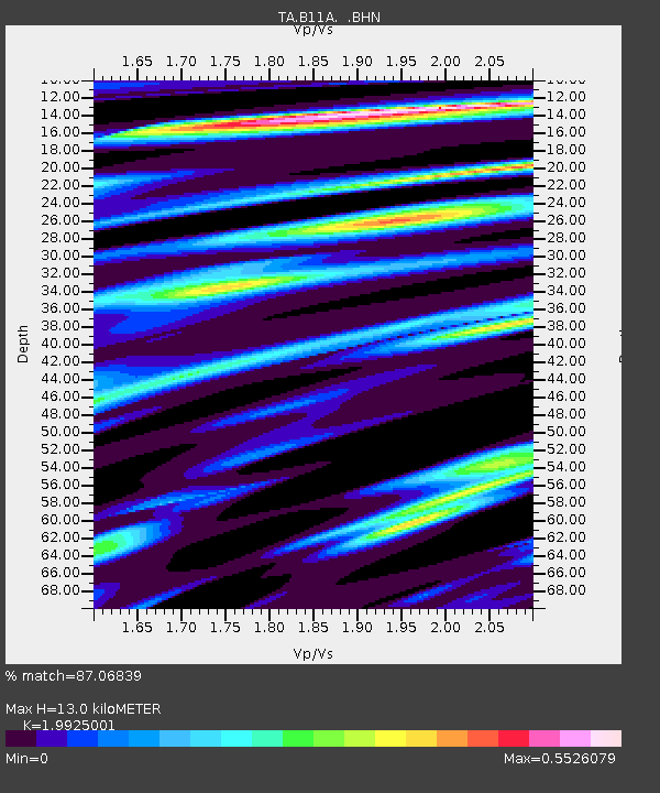
| Estimated Moho Depth: |
13.0 km |
| Estimated Crust Vp/Vs: |
1.99 |
| Assumed Crust Vp: |
6.571 km/s |
| Estimated Crust Vs: |
3.298 km/s |
| Estimated Crust Poisson's Ratio: |
0.33 |
|
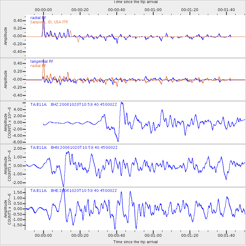
| Radial Match: |
87.06839 % |
| Radial Bump: |
305 |
| Transverse Match: |
78.318825 % |
| Transverse Bump: |
400 |
| SOD ConfigId: |
2564 |
| Insert Time: |
2010-03-07 03:04:19.281 +0000 |
| GWidth: |
2.5 |
| Max Bumps: |
400 |
| Tol: |
0.001 |
|
Signal To Noise
| Channel | StoN | STA | LTA |
| TA:B11A: :BHN:20061020T10:59:40.450002Z | 2.6481194 | 5.5018296E-7 | 2.0776365E-7 |
| TA:B11A: :BHE:20061020T10:59:40.450002Z | 3.0065398 | 4.402571E-7 | 1.4643317E-7 |
| TA:B11A: :BHZ:20061020T10:59:40.450002Z | 5.7728395 | 1.36572E-6 | 2.3657681E-7 |
| Arrivals |
| Ps | 2.0 SECOND |
| PpPs | 5.7 SECOND |
| PsPs/PpSs | 7.8 SECOND |


