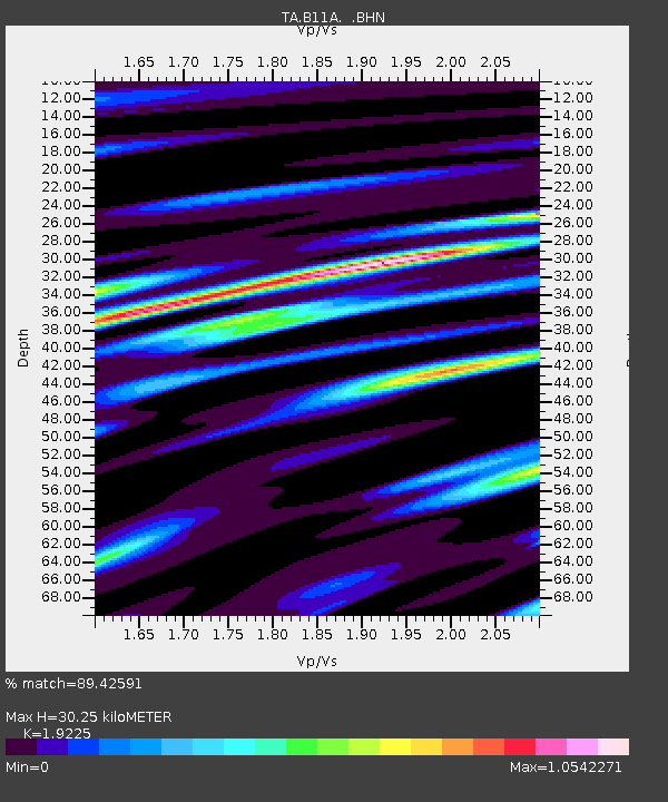
B11A Sanpoint, ID, USA - Earthquake Result Viewer
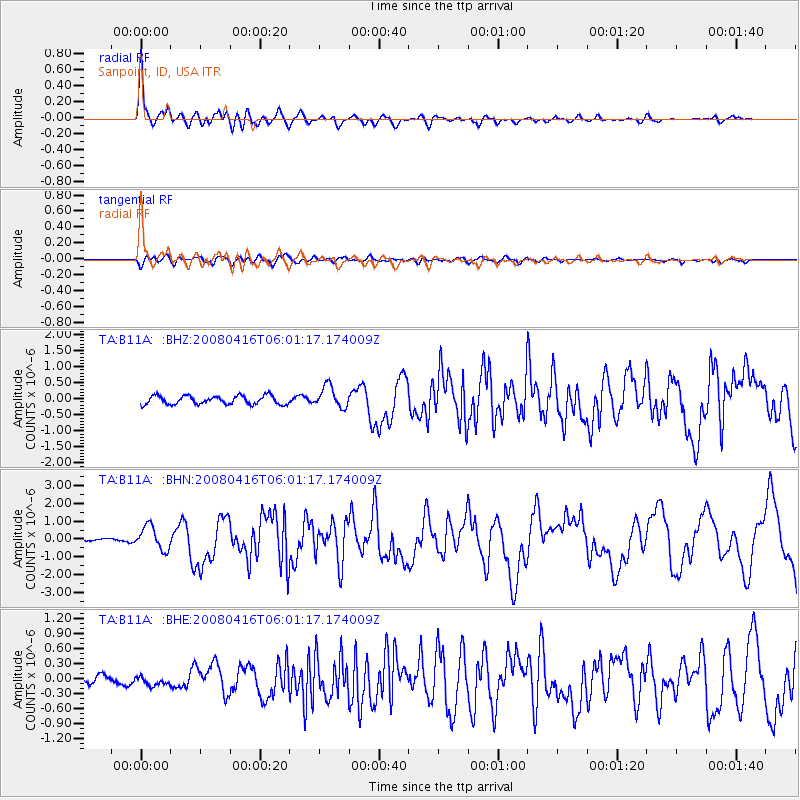
Earthquake location: Andreanof Islands, Aleutian Is.
Earthquake latitude/longitude: 51.9/-179.2
Earthquake time(UTC): 2008/04/16 (107) 05:54:19 GMT
Earthquake Depth: 13 km
Earthquake Magnitude: 6.1 MB, 6.5 MS, 6.6 MW, 6.6 MW
Earthquake Catalog/Contributor: WHDF/NEIC
Network: TA USArray Transportable Network (new EarthScope stations)
Station: B11A Sanpoint, ID, USA
Lat/Lon: 48.44 N/116.37 W
Elevation: 870 m
Distance: 39.3 deg
Az: 69.32 deg
Baz: 299.438 deg
Ray Param: 0.075069346
Estimated Moho Depth: 30.25 km
Estimated Crust Vp/Vs: 1.92
Assumed Crust Vp: 6.571 km/s
Estimated Crust Vs: 3.418 km/s
Estimated Crust Poisson's Ratio: 0.31
Radial Match: 89.42591 %
Radial Bump: 400
Transverse Match: 76.41783 %
Transverse Bump: 400
SOD ConfigId: 2504
Insert Time: 2010-03-07 03:04:23.333 +0000
GWidth: 2.5
Max Bumps: 400
Tol: 0.001

Signal To Noise

ChannelStoNSTALTA
TA:B11A: :BHN:20080416T06:01:17.174009Z4.33185156.6808377E-71.5422592E-7
TA:B11A: :BHE:20080416T06:01:17.174009Z0.744885568.061057E-81.08218735E-7
TA:B11A: :BHZ:20080416T06:01:17.174009Z2.52849223.3504145E-71.3250643E-7
Arrivals
Ps4.5 SECOND
PpPs13 SECOND
PsPs/PpSs17 SECOND