You are here: Home > Network List > TA - USArray Transportable Network (new EarthScope stations) Stations List
> Station B11A Sanpoint, ID, USA > Earthquake Result Viewer
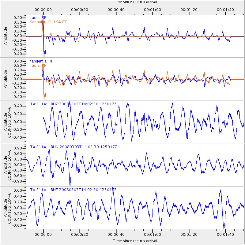
B11A Sanpoint, ID, USA - Earthquake Result Viewer
*The percent match for this event was below the threshold and hence no stack was calculated.
| Earthquake location: |
Philippine Islands Region |
| Earthquake latitude/longitude: |
19.9/121.3 |
| Earthquake time(UTC): |
2008/03/03 (063) 13:49:40 GMT |
| Earthquake Depth: |
10 km |
| Earthquake Magnitude: |
6.0 MB, 6.0 MW, 5.9 MW |
| Earthquake Catalog/Contributor: |
WHDF/NEIC |
|
| Network: |
TA USArray Transportable Network (new EarthScope stations) |
| Station: |
B11A Sanpoint, ID, USA |
| Lat/Lon: |
48.44 N/116.37 W |
| Elevation: |
870 m |
|
| Distance: |
94.7 deg |
| Az: |
34.39 deg |
| Baz: |
307.055 deg |
| Ray Param: |
$rayparam |
*The percent match for this event was below the threshold and hence was not used in the summary stack. |
|
| Radial Match: |
63.726692 % |
| Radial Bump: |
400 |
| Transverse Match: |
64.11917 % |
| Transverse Bump: |
400 |
| SOD ConfigId: |
2504 |
| Insert Time: |
2010-03-07 03:04:55.707 +0000 |
| GWidth: |
2.5 |
| Max Bumps: |
400 |
| Tol: |
0.001 |
|
Signal To Noise
| Channel | StoN | STA | LTA |
| TA:B11A: :BHN:20080303T14:02:30.125017Z | 1.7226357 | 4.8658524E-7 | 2.8246555E-7 |
| TA:B11A: :BHE:20080303T14:02:30.125017Z | 1.2171243 | 2.7444887E-7 | 2.254896E-7 |
| TA:B11A: :BHZ:20080303T14:02:30.125017Z | 0.96180534 | 2.2970293E-7 | 2.3882475E-7 |
| Arrivals |
| Ps | |
| PpPs | |
| PsPs/PpSs | |


