You are here: Home > Network List > TA - USArray Transportable Network (new EarthScope stations) Stations List
> Station B11A Sanpoint, ID, USA > Earthquake Result Viewer
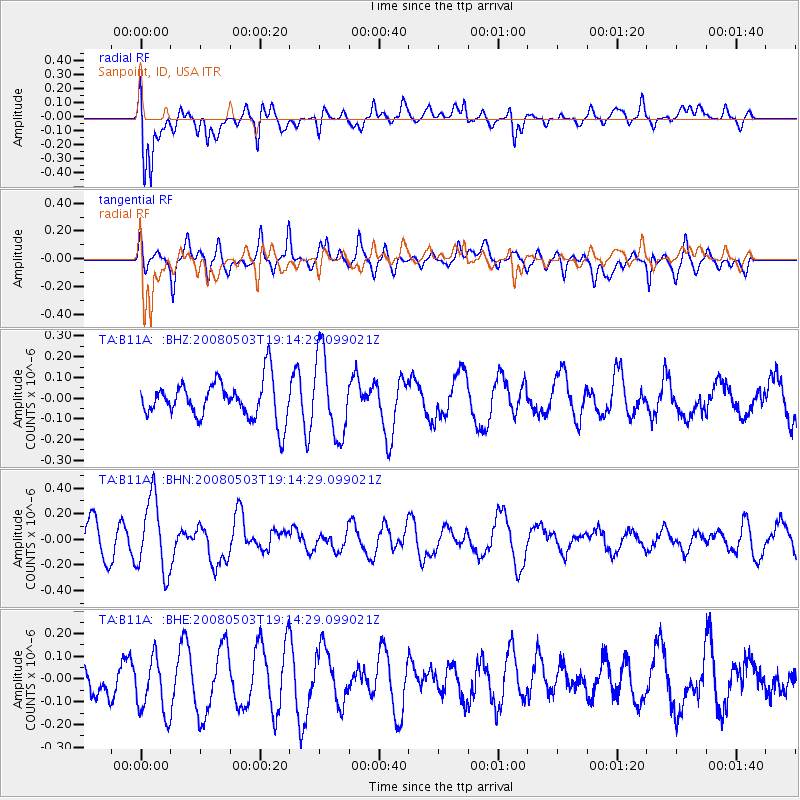
B11A Sanpoint, ID, USA - Earthquake Result Viewer
*The percent match for this event was below the threshold and hence no stack was calculated.
| Earthquake location: |
Solomon Islands |
| Earthquake latitude/longitude: |
-6.6/155.1 |
| Earthquake time(UTC): |
2008/05/03 (124) 19:01:46 GMT |
| Earthquake Depth: |
35 km |
| Earthquake Magnitude: |
5.8 MW, 5.4 MS, 5.4 MB, 5.7 MW |
| Earthquake Catalog/Contributor: |
WHDF/NEIC |
|
| Network: |
TA USArray Transportable Network (new EarthScope stations) |
| Station: |
B11A Sanpoint, ID, USA |
| Lat/Lon: |
48.44 N/116.37 W |
| Elevation: |
870 m |
|
| Distance: |
93.9 deg |
| Az: |
41.86 deg |
| Baz: |
264.515 deg |
| Ray Param: |
$rayparam |
*The percent match for this event was below the threshold and hence was not used in the summary stack. |
|
| Radial Match: |
73.84568 % |
| Radial Bump: |
400 |
| Transverse Match: |
64.2993 % |
| Transverse Bump: |
400 |
| SOD ConfigId: |
2504 |
| Insert Time: |
2010-03-07 03:04:59.579 +0000 |
| GWidth: |
2.5 |
| Max Bumps: |
400 |
| Tol: |
0.001 |
|
Signal To Noise
| Channel | StoN | STA | LTA |
| TA:B11A: :BHN:20080503T19:14:29.099021Z | 2.860116 | 2.8691966E-7 | 1.0031749E-7 |
| TA:B11A: :BHE:20080503T19:14:29.099021Z | 1.5401485 | 1.3314452E-7 | 8.644915E-8 |
| TA:B11A: :BHZ:20080503T19:14:29.099021Z | 2.1202488 | 1.9419147E-7 | 9.1589E-8 |
| Arrivals |
| Ps | |
| PpPs | |
| PsPs/PpSs | |


