You are here: Home > Network List > TS - TERRAscope (Southern California Seismic Network) Stations List
> Station ISA Isabella, California, USA > Earthquake Result Viewer
ISA Isabella, California, USA - Earthquake Result Viewer
| Earthquake location: |
Santa Cruz Islands |
| Earthquake latitude/longitude: |
-10.9/166.0 |
| Earthquake time(UTC): |
1996/09/14 (258) 13:10:53 GMT |
| Earthquake Depth: |
73 km |
| Earthquake Magnitude: |
6.0 MB, 6.0 MS, 6.4 UNKNOWN, 6.4 MW |
| Earthquake Catalog/Contributor: |
WHDF/NEIC |
|
| Network: |
TS TERRAscope (Southern California Seismic Network) |
| Station: |
ISA Isabella, California, USA |
| Lat/Lon: |
35.66 N/118.47 W |
| Elevation: |
835 m |
|
| Distance: |
84.8 deg |
| Az: |
52.352 deg |
| Baz: |
252.763 deg |
| Ray Param: |
0.04509136 |
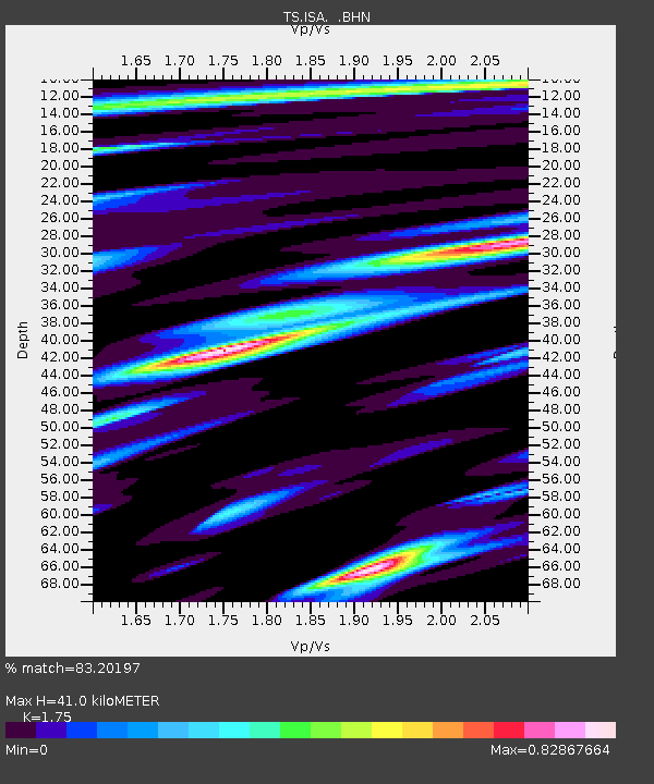
| Estimated Moho Depth: |
41.0 km |
| Estimated Crust Vp/Vs: |
1.75 |
| Assumed Crust Vp: |
6.1 km/s |
| Estimated Crust Vs: |
3.486 km/s |
| Estimated Crust Poisson's Ratio: |
0.26 |
|
| Radial Match: |
83.20197 % |
| Radial Bump: |
400 |
| Transverse Match: |
68.42472 % |
| Transverse Bump: |
400 |
| SOD ConfigId: |
6273 |
| Insert Time: |
2010-02-26 14:24:53.567 +0000 |
| GWidth: |
2.5 |
| Max Bumps: |
400 |
| Tol: |
0.001 |
|

Signal To Noise
| Channel | StoN | STA | LTA |
| TS:ISA: :BHN:19960914T13:22:49.084021Z | 0.89539486 | 1.4483197E-7 | 1.6175207E-7 |
| TS:ISA: :BHE:19960914T13:22:49.084021Z | 5.5900693 | 6.455594E-7 | 1.15483246E-7 |
| TS:ISA: :BHZ:19960914T13:22:49.084021Z | 15.6663 | 2.026142E-6 | 1.2933126E-7 |
| Arrivals |
| Ps | 5.2 SECOND |
| PpPs | 18 SECOND |
| PsPs/PpSs | 23 SECOND |


