You are here: Home > Network List > US - United States National Seismic Network Stations List
> Station AMTX Amarillo, Texas, USA > Earthquake Result Viewer
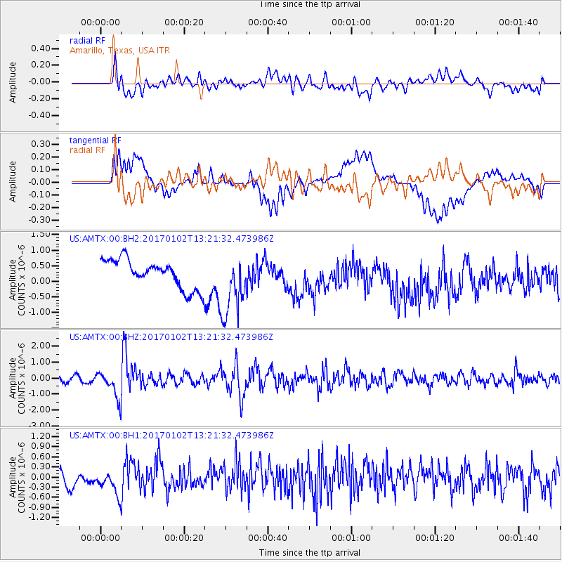
AMTX Amarillo, Texas, USA - Earthquake Result Viewer
*The percent match for this event was below the threshold and hence no stack was calculated.
| Earthquake location: |
Northern Peru |
| Earthquake latitude/longitude: |
-4.9/-76.3 |
| Earthquake time(UTC): |
2017/01/02 (002) 13:13:48 GMT |
| Earthquake Depth: |
108 km |
| Earthquake Magnitude: |
5.9 Mwb |
| Earthquake Catalog/Contributor: |
NEIC PDE/us |
|
| Network: |
US United States National Seismic Network |
| Station: |
AMTX Amarillo, Texas, USA |
| Lat/Lon: |
34.53 N/101.41 W |
| Elevation: |
1010 m |
|
| Distance: |
45.8 deg |
| Az: |
330.786 deg |
| Baz: |
143.911 deg |
| Ray Param: |
$rayparam |
*The percent match for this event was below the threshold and hence was not used in the summary stack. |
|
| Radial Match: |
55.395794 % |
| Radial Bump: |
400 |
| Transverse Match: |
37.991028 % |
| Transverse Bump: |
400 |
| SOD ConfigId: |
1943534 |
| Insert Time: |
2017-01-16 13:18:02.084 +0000 |
| GWidth: |
2.5 |
| Max Bumps: |
400 |
| Tol: |
0.001 |
|
Signal To Noise
| Channel | StoN | STA | LTA |
| US:AMTX:00:BHZ:20170102T13:21:32.473986Z | 4.3815746 | 8.704131E-7 | 1.9865304E-7 |
| US:AMTX:00:BH1:20170102T13:21:32.473986Z | 1.945942 | 3.8160937E-7 | 1.961052E-7 |
| US:AMTX:00:BH2:20170102T13:21:32.473986Z | 2.9298182 | 1.1458734E-6 | 3.911073E-7 |
| Arrivals |
| Ps | |
| PpPs | |
| PsPs/PpSs | |


