You are here: Home > Network List > TA - USArray Transportable Network (new EarthScope stations) Stations List
> Station C10A Spilker Farm, Colbert, WA, USA > Earthquake Result Viewer
C10A Spilker Farm, Colbert, WA, USA - Earthquake Result Viewer
| Earthquake location: |
Near Coast Of Peru |
| Earthquake latitude/longitude: |
-13.6/-76.6 |
| Earthquake time(UTC): |
2007/08/19 (231) 01:22:40 GMT |
| Earthquake Depth: |
26 km |
| Earthquake Magnitude: |
5.9 MB, 5.4 MS, 5.8 MW, 5.5 ML |
| Earthquake Catalog/Contributor: |
WHDF/NEIC |
|
| Network: |
TA USArray Transportable Network (new EarthScope stations) |
| Station: |
C10A Spilker Farm, Colbert, WA, USA |
| Lat/Lon: |
47.82 N/117.31 W |
| Elevation: |
684 m |
|
| Distance: |
71.1 deg |
| Az: |
332.326 deg |
| Baz: |
137.935 deg |
| Ray Param: |
0.05450808 |
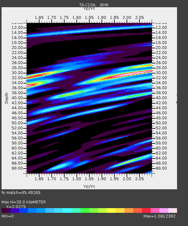
| Estimated Moho Depth: |
30.0 km |
| Estimated Crust Vp/Vs: |
2.03 |
| Assumed Crust Vp: |
6.571 km/s |
| Estimated Crust Vs: |
3.241 km/s |
| Estimated Crust Poisson's Ratio: |
0.34 |
|
| Radial Match: |
85.49265 % |
| Radial Bump: |
400 |
| Transverse Match: |
59.397095 % |
| Transverse Bump: |
400 |
| SOD ConfigId: |
2564 |
| Insert Time: |
2010-03-07 03:05:33.606 +0000 |
| GWidth: |
2.5 |
| Max Bumps: |
400 |
| Tol: |
0.001 |
|

Signal To Noise
| Channel | StoN | STA | LTA |
| TA:C10A: :BHN:20070819T01:33:25.500027Z | 2.8115005 | 3.1934056E-7 | 1.13583674E-7 |
| TA:C10A: :BHE:20070819T01:33:25.500027Z | 2.8164804 | 2.4860194E-7 | 8.826689E-8 |
| TA:C10A: :BHZ:20070819T01:33:25.500027Z | 6.991046 | 5.31353E-7 | 7.6004795E-8 |
| Arrivals |
| Ps | 4.8 SECOND |
| PpPs | 13 SECOND |
| PsPs/PpSs | 18 SECOND |


