You are here: Home > Network List > TA - USArray Transportable Network (new EarthScope stations) Stations List
> Station D25K Kavik River, AK, USA > Earthquake Result Viewer
D25K Kavik River, AK, USA - Earthquake Result Viewer
| Earthquake location: |
Hindu Kush Region, Afghanistan |
| Earthquake latitude/longitude: |
36.5/70.0 |
| Earthquake time(UTC): |
2019/08/08 (220) 00:45:26 GMT |
| Earthquake Depth: |
222 km |
| Earthquake Magnitude: |
5.8 Mww |
| Earthquake Catalog/Contributor: |
NEIC PDE/us |
|
| Network: |
TA USArray Transportable Network (new EarthScope stations) |
| Station: |
D25K Kavik River, AK, USA |
| Lat/Lon: |
69.32 N/146.38 W |
| Elevation: |
770 m |
|
| Distance: |
71.1 deg |
| Az: |
12.88 deg |
| Baz: |
329.644 deg |
| Ray Param: |
0.053931393 |
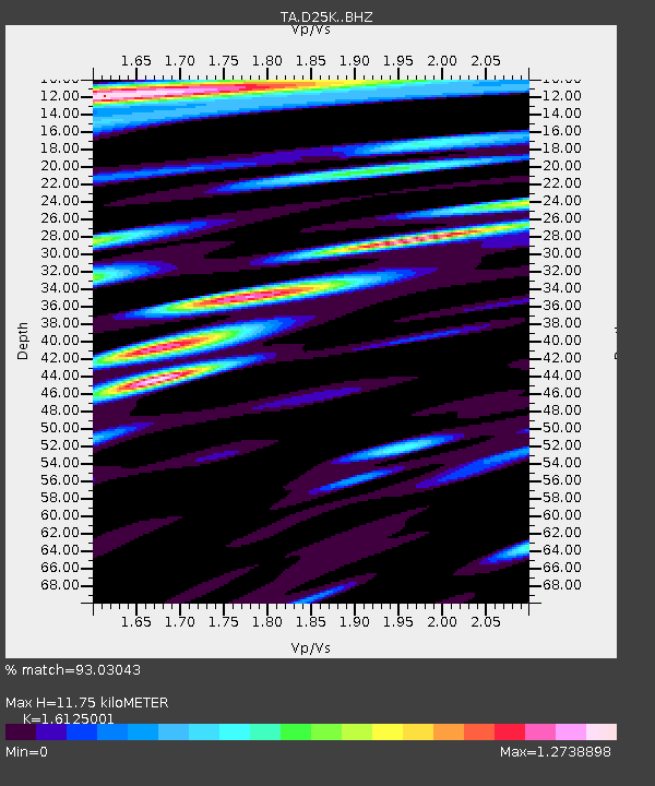
| Estimated Moho Depth: |
11.75 km |
| Estimated Crust Vp/Vs: |
1.61 |
| Assumed Crust Vp: |
6.378 km/s |
| Estimated Crust Vs: |
3.956 km/s |
| Estimated Crust Poisson's Ratio: |
0.19 |
|
| Radial Match: |
93.03043 % |
| Radial Bump: |
400 |
| Transverse Match: |
91.982605 % |
| Transverse Bump: |
400 |
| SOD ConfigId: |
19053131 |
| Insert Time: |
2019-08-22 00:54:51.125 +0000 |
| GWidth: |
2.5 |
| Max Bumps: |
400 |
| Tol: |
0.001 |
|
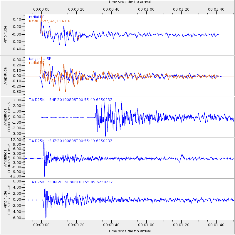
Signal To Noise
| Channel | StoN | STA | LTA |
| TA:D25K: :BHZ:20190808T00:55:49.625023Z | 78.83786 | 4.387915E-6 | 5.5657456E-8 |
| TA:D25K: :BHN:20190808T00:55:49.625023Z | 44.95826 | 1.959445E-6 | 4.3583647E-8 |
| TA:D25K: :BHE:20190808T00:55:49.625023Z | 23.183596 | 1.0601972E-6 | 4.5730488E-8 |
| Arrivals |
| Ps | 1.2 SECOND |
| PpPs | 4.6 SECOND |
| PsPs/PpSs | 5.8 SECOND |


