You are here: Home > Network List > TA - USArray Transportable Network (new EarthScope stations) Stations List
> Station E20K Nigu River, AK, USA > Earthquake Result Viewer
E20K Nigu River, AK, USA - Earthquake Result Viewer
| Earthquake location: |
Hindu Kush Region, Afghanistan |
| Earthquake latitude/longitude: |
36.5/70.0 |
| Earthquake time(UTC): |
2019/08/08 (220) 00:45:26 GMT |
| Earthquake Depth: |
222 km |
| Earthquake Magnitude: |
5.8 Mww |
| Earthquake Catalog/Contributor: |
NEIC PDE/us |
|
| Network: |
TA USArray Transportable Network (new EarthScope stations) |
| Station: |
E20K Nigu River, AK, USA |
| Lat/Lon: |
68.26 N/156.19 W |
| Elevation: |
866 m |
|
| Distance: |
70.0 deg |
| Az: |
16.643 deg |
| Baz: |
321.755 deg |
| Ray Param: |
0.054665 |
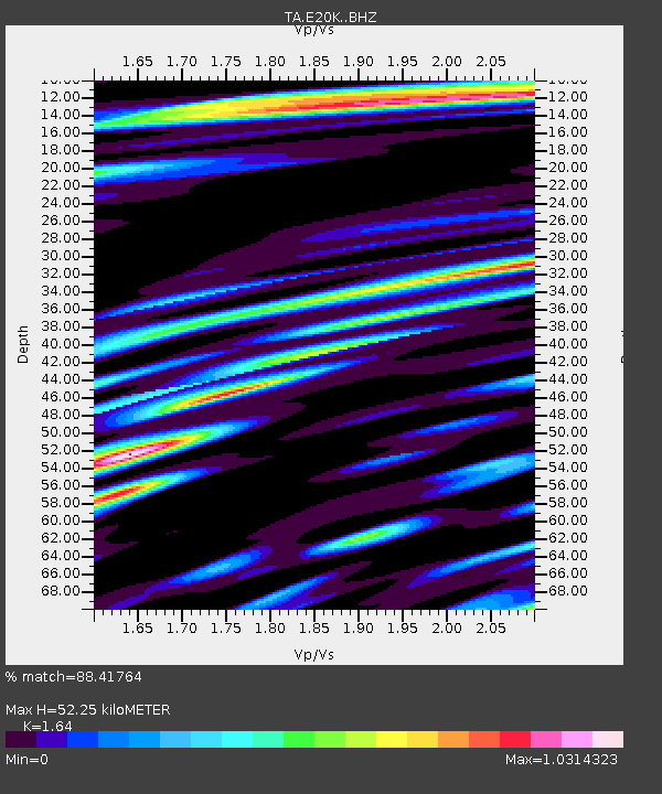
| Estimated Moho Depth: |
52.25 km |
| Estimated Crust Vp/Vs: |
1.64 |
| Assumed Crust Vp: |
6.221 km/s |
| Estimated Crust Vs: |
3.793 km/s |
| Estimated Crust Poisson's Ratio: |
0.20 |
|
| Radial Match: |
88.41764 % |
| Radial Bump: |
400 |
| Transverse Match: |
78.2675 % |
| Transverse Bump: |
400 |
| SOD ConfigId: |
19053131 |
| Insert Time: |
2019-08-22 00:54:54.629 +0000 |
| GWidth: |
2.5 |
| Max Bumps: |
400 |
| Tol: |
0.001 |
|
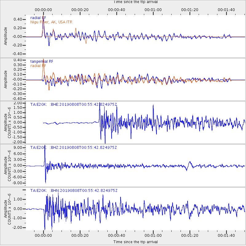
Signal To Noise
| Channel | StoN | STA | LTA |
| TA:E20K: :BHZ:20190808T00:55:42.824975Z | 58.44888 | 3.0444517E-6 | 5.2087426E-8 |
| TA:E20K: :BHN:20190808T00:55:42.824975Z | 17.208035 | 8.6297763E-7 | 5.014969E-8 |
| TA:E20K: :BHE:20190808T00:55:42.824975Z | 20.117245 | 8.380904E-7 | 4.1660297E-8 |
| Arrivals |
| Ps | 5.6 SECOND |
| PpPs | 21 SECOND |
| PsPs/PpSs | 27 SECOND |


