You are here: Home > Network List > TA - USArray Transportable Network (new EarthScope stations) Stations List
> Station I23K Minto, Yukon-Koyukuk, AK, USA > Earthquake Result Viewer
I23K Minto, Yukon-Koyukuk, AK, USA - Earthquake Result Viewer
| Earthquake location: |
Hindu Kush Region, Afghanistan |
| Earthquake latitude/longitude: |
36.5/70.0 |
| Earthquake time(UTC): |
2019/08/08 (220) 00:45:26 GMT |
| Earthquake Depth: |
222 km |
| Earthquake Magnitude: |
5.8 Mww |
| Earthquake Catalog/Contributor: |
NEIC PDE/us |
|
| Network: |
TA USArray Transportable Network (new EarthScope stations) |
| Station: |
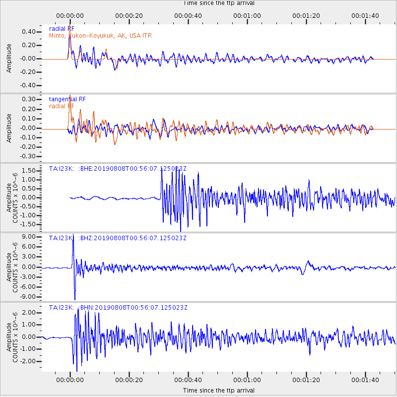
I23K Minto, Yukon-Koyukuk, AK, USA |
| Lat/Lon: |
65.15 N/149.36 W |
| Elevation: |
149 m |
|
| Distance: |
74.1 deg |
| Az: |
16.199 deg |
| Baz: |
327.886 deg |
| Ray Param: |
0.051974297 |
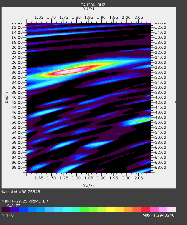
| Estimated Moho Depth: |
29.25 km |
| Estimated Crust Vp/Vs: |
1.77 |
| Assumed Crust Vp: |
6.566 km/s |
| Estimated Crust Vs: |
3.71 km/s |
| Estimated Crust Poisson's Ratio: |
0.27 |
|
| Radial Match: |
88.25545 % |
| Radial Bump: |
400 |
| Transverse Match: |
82.088036 % |
| Transverse Bump: |
400 |
| SOD ConfigId: |
19053131 |
| Insert Time: |
2019-08-22 00:55:29.910 +0000 |
| GWidth: |
2.5 |
| Max Bumps: |
400 |
| Tol: |
0.001 |
|
Signal To Noise
| Channel | StoN | STA | LTA |
| TA:I23K: :BHZ:20190808T00:56:07.125023Z | 77.14693 | 3.429658E-6 | 4.4456183E-8 |
| TA:I23K: :BHN:20190808T00:56:07.125023Z | 18.230793 | 1.1674974E-6 | 6.403986E-8 |
| TA:I23K: :BHE:20190808T00:56:07.125023Z | 15.054362 | 7.111372E-7 | 4.7237947E-8 |
| Arrivals |
| Ps | 3.5 SECOND |
| PpPs | 12 SECOND |
| PsPs/PpSs | 15 SECOND |


