You are here: Home > Network List > TA - USArray Transportable Network (new EarthScope stations) Stations List
> Station C10A Spilker Farm, Colbert, WA, USA > Earthquake Result Viewer
C10A Spilker Farm, Colbert, WA, USA - Earthquake Result Viewer

| Earthquake location: |
Santiago Del Estero Prov., Arg. |
| Earthquake latitude/longitude: |
-26.9/-63.1 |
| Earthquake time(UTC): |
2006/09/22 (265) 02:32:25 GMT |
| Earthquake Depth: |
598 km |
| Earthquake Magnitude: |
6.1 MB, 6.0 MW, 6.0 MW |
| Earthquake Catalog/Contributor: |
WHDF/NEIC |
|
| Network: |
TA USArray Transportable Network (new EarthScope stations) |
| Station: |
C10A Spilker Farm, Colbert, WA, USA |
| Lat/Lon: |
47.82 N/117.31 W |
| Elevation: |
684 m |
|
| Distance: |
88.8 deg |
| Az: |
326.877 deg |
| Baz: |
133.592 deg |
| Ray Param: |
0.041622523 |
| Estimated Moho Depth: |
26.75 km |
| Estimated Crust Vp/Vs: |
1.78 |
| Assumed Crust Vp: |
6.571 km/s |
| Estimated Crust Vs: |
3.691 km/s |
| Estimated Crust Poisson's Ratio: |
0.27 |
|
| Radial Match: |
80.22871 % |
| Radial Bump: |
400 |
| Transverse Match: |
64.601814 % |
| Transverse Bump: |
400 |
| SOD ConfigId: |
2665 |
| Insert Time: |
2010-03-07 03:06:30.929 +0000 |
| GWidth: |
2.5 |
| Max Bumps: |
400 |
| Tol: |
0.001 |
|
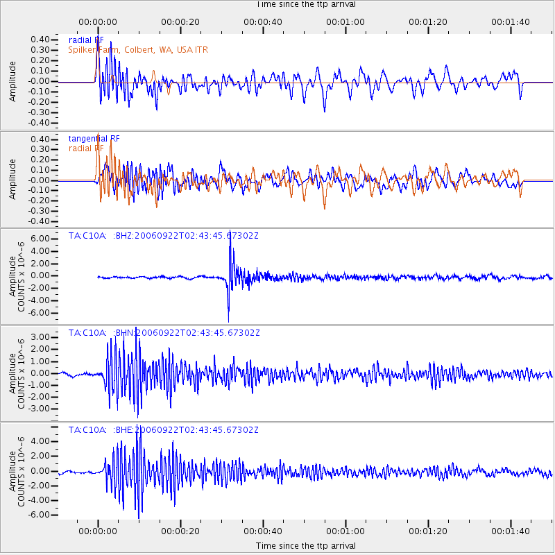
Signal To Noise
| Channel | StoN | STA | LTA |
| TA:C10A: :BHN:20060922T02:43:45.67302Z | 11.823031 | 1.3454994E-6 | 1.1380325E-7 |
| TA:C10A: :BHE:20060922T02:43:45.67302Z | 8.249898 | 1.4699981E-6 | 1.781838E-7 |
| TA:C10A: :BHZ:20060922T02:43:45.67302Z | 17.81059 | 2.2253241E-6 | 1.2494387E-7 |
| Arrivals |
| Ps | 3.2 SECOND |
| PpPs | 11 SECOND |
| PsPs/PpSs | 14 SECOND |


