You are here: Home > Network List > TA - USArray Transportable Network (new EarthScope stations) Stations List
> Station C10A Spilker Farm, Colbert, WA, USA > Earthquake Result Viewer
C10A Spilker Farm, Colbert, WA, USA - Earthquake Result Viewer
| Earthquake location: |
Andreanof Islands, Aleutian Is. |
| Earthquake latitude/longitude: |
51.9/-179.4 |
| Earthquake time(UTC): |
2008/04/15 (106) 22:59:51 GMT |
| Earthquake Depth: |
10 km |
| Earthquake Magnitude: |
6.1 MB, 6.4 MS, 6.4 MW, 6.4 MW |
| Earthquake Catalog/Contributor: |
WHDF/NEIC |
|
| Network: |
TA USArray Transportable Network (new EarthScope stations) |
| Station: |
C10A Spilker Farm, Colbert, WA, USA |
| Lat/Lon: |
47.82 N/117.31 W |
| Elevation: |
684 m |
|
| Distance: |
39.2 deg |
| Az: |
70.533 deg |
| Baz: |
299.809 deg |
| Ray Param: |
0.07514714 |
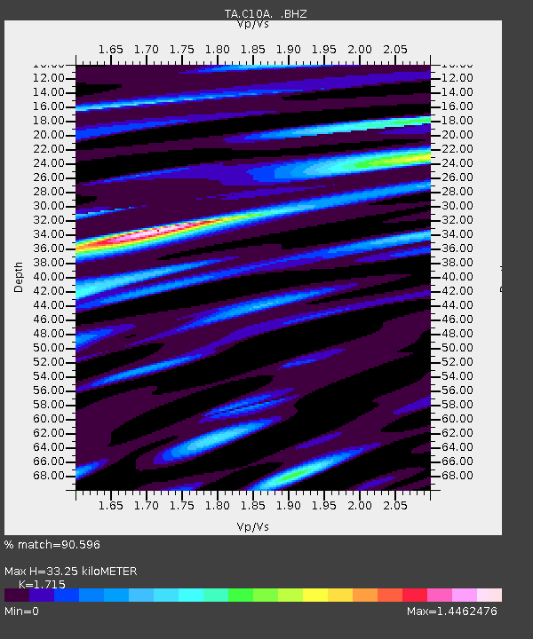
| Estimated Moho Depth: |
33.25 km |
| Estimated Crust Vp/Vs: |
1.72 |
| Assumed Crust Vp: |
6.571 km/s |
| Estimated Crust Vs: |
3.831 km/s |
| Estimated Crust Poisson's Ratio: |
0.24 |
|
| Radial Match: |
90.596 % |
| Radial Bump: |
400 |
| Transverse Match: |
66.47862 % |
| Transverse Bump: |
400 |
| SOD ConfigId: |
2504 |
| Insert Time: |
2010-03-07 03:06:37.648 +0000 |
| GWidth: |
2.5 |
| Max Bumps: |
400 |
| Tol: |
0.001 |
|

Signal To Noise
| Channel | StoN | STA | LTA |
| TA:C10A: :BHZ:20080415T23:06:48.300012Z | 5.4221835 | 8.905513E-7 | 1.642422E-7 |
| TA:C10A: :BHN:20080415T23:06:48.300012Z | 2.0436227 | 3.603322E-7 | 1.7632031E-7 |
| TA:C10A: :BHE:20080415T23:06:48.300012Z | 3.9445593 | 5.463538E-7 | 1.385082E-7 |
| Arrivals |
| Ps | 3.9 SECOND |
| PpPs | 13 SECOND |
| PsPs/PpSs | 17 SECOND |


