You are here: Home > Network List > TA - USArray Transportable Network (new EarthScope stations) Stations List
> Station M18K Stony River, AK, USA > Earthquake Result Viewer
M18K Stony River, AK, USA - Earthquake Result Viewer
| Earthquake location: |
Hindu Kush Region, Afghanistan |
| Earthquake latitude/longitude: |
36.5/70.0 |
| Earthquake time(UTC): |
2019/08/08 (220) 00:45:26 GMT |
| Earthquake Depth: |
222 km |
| Earthquake Magnitude: |
5.8 Mww |
| Earthquake Catalog/Contributor: |
NEIC PDE/us |
|
| Network: |
TA USArray Transportable Network (new EarthScope stations) |
| Station: |
M18K Stony River, AK, USA |
| Lat/Lon: |
61.49 N/155.82 W |
| Elevation: |
289 m |
|
| Distance: |
75.5 deg |
| Az: |
20.84 deg |
| Baz: |
323.335 deg |
| Ray Param: |
0.051065017 |
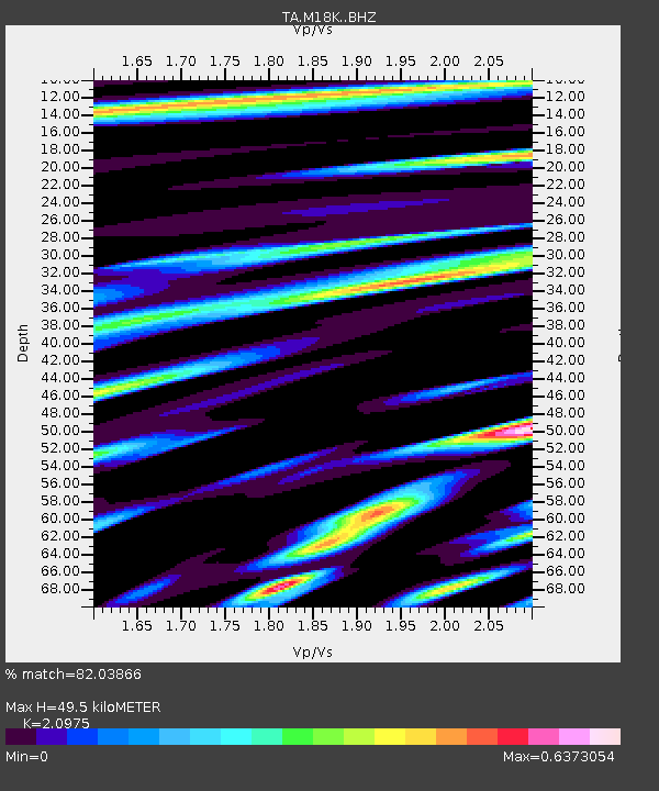
| Estimated Moho Depth: |
49.5 km |
| Estimated Crust Vp/Vs: |
2.10 |
| Assumed Crust Vp: |
6.566 km/s |
| Estimated Crust Vs: |
3.13 km/s |
| Estimated Crust Poisson's Ratio: |
0.35 |
|
| Radial Match: |
82.03866 % |
| Radial Bump: |
400 |
| Transverse Match: |
69.23962 % |
| Transverse Bump: |
400 |
| SOD ConfigId: |
19053131 |
| Insert Time: |
2019-08-22 00:55:55.442 +0000 |
| GWidth: |
2.5 |
| Max Bumps: |
400 |
| Tol: |
0.001 |
|

Signal To Noise
| Channel | StoN | STA | LTA |
| TA:M18K: :BHZ:20190808T00:56:15.000023Z | 29.15464 | 1.5193884E-6 | 5.2114807E-8 |
| TA:M18K: :BHN:20190808T00:56:15.000023Z | 11.602427 | 5.993881E-7 | 5.1660585E-8 |
| TA:M18K: :BHE:20190808T00:56:15.000023Z | 8.767122 | 3.6181103E-7 | 4.126908E-8 |
| Arrivals |
| Ps | 8.5 SECOND |
| PpPs | 23 SECOND |
| PsPs/PpSs | 31 SECOND |


