You are here: Home > Network List > TA - USArray Transportable Network (new EarthScope stations) Stations List
> Station M20K Styx River, AK, USA > Earthquake Result Viewer
M20K Styx River, AK, USA - Earthquake Result Viewer
| Earthquake location: |
Hindu Kush Region, Afghanistan |
| Earthquake latitude/longitude: |
36.5/70.0 |
| Earthquake time(UTC): |
2019/08/08 (220) 00:45:26 GMT |
| Earthquake Depth: |
222 km |
| Earthquake Magnitude: |
5.8 Mww |
| Earthquake Catalog/Contributor: |
NEIC PDE/us |
|
| Network: |
TA USArray Transportable Network (new EarthScope stations) |
| Station: |
M20K Styx River, AK, USA |
| Lat/Lon: |
61.88 N/153.13 W |
| Elevation: |
1107 m |
|
| Distance: |
75.9 deg |
| Az: |
19.528 deg |
| Baz: |
325.376 deg |
| Ray Param: |
0.050781008 |
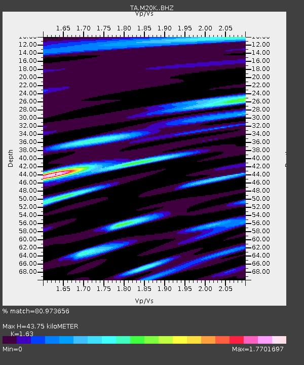
| Estimated Moho Depth: |
43.75 km |
| Estimated Crust Vp/Vs: |
1.63 |
| Assumed Crust Vp: |
6.566 km/s |
| Estimated Crust Vs: |
4.028 km/s |
| Estimated Crust Poisson's Ratio: |
0.20 |
|
| Radial Match: |
80.973656 % |
| Radial Bump: |
400 |
| Transverse Match: |
68.27959 % |
| Transverse Bump: |
400 |
| SOD ConfigId: |
19053131 |
| Insert Time: |
2019-08-22 00:55:55.853 +0000 |
| GWidth: |
2.5 |
| Max Bumps: |
400 |
| Tol: |
0.001 |
|

Signal To Noise
| Channel | StoN | STA | LTA |
| TA:M20K: :BHZ:20190808T00:56:17.425011Z | 16.48831 | 1.1098791E-6 | 6.7313096E-8 |
| TA:M20K: :BHN:20190808T00:56:17.425011Z | 8.588185 | 3.6694118E-7 | 4.2726278E-8 |
| TA:M20K: :BHE:20190808T00:56:17.425011Z | 8.405159 | 3.6438578E-7 | 4.3352635E-8 |
| Arrivals |
| Ps | 4.3 SECOND |
| PpPs | 17 SECOND |
| PsPs/PpSs | 21 SECOND |


