You are here: Home > Network List > TA - USArray Transportable Network (new EarthScope stations) Stations List
> Station N16K Nishlik Lake, AK, USA > Earthquake Result Viewer
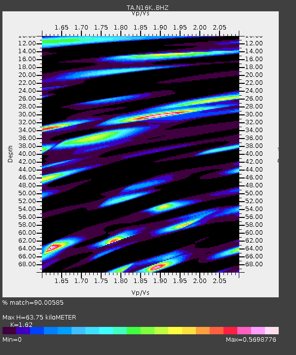
N16K Nishlik Lake, AK, USA - Earthquake Result Viewer
| Earthquake location: |
Hindu Kush Region, Afghanistan |
| Earthquake latitude/longitude: |
36.5/70.0 |
| Earthquake time(UTC): |
2019/08/08 (220) 00:45:26 GMT |
| Earthquake Depth: |
222 km |
| Earthquake Magnitude: |
5.8 Mww |
| Earthquake Catalog/Contributor: |
NEIC PDE/us |
|
| Network: |
TA USArray Transportable Network (new EarthScope stations) |
| Station: |
N16K Nishlik Lake, AK, USA |
| Lat/Lon: |
60.47 N/158.77 W |
| Elevation: |
582 m |
|
| Distance: |
75.4 deg |
| Az: |
22.659 deg |
| Baz: |
321.221 deg |
| Ray Param: |
0.051112562 |
| Estimated Moho Depth: |
63.75 km |
| Estimated Crust Vp/Vs: |
1.62 |
| Assumed Crust Vp: |
6.276 km/s |
| Estimated Crust Vs: |
3.874 km/s |
| Estimated Crust Poisson's Ratio: |
0.19 |
|
| Radial Match: |
90.00585 % |
| Radial Bump: |
400 |
| Transverse Match: |
84.06472 % |
| Transverse Bump: |
400 |
| SOD ConfigId: |
19053131 |
| Insert Time: |
2019-08-22 00:56:03.818 +0000 |
| GWidth: |
2.5 |
| Max Bumps: |
400 |
| Tol: |
0.001 |
|

Signal To Noise
| Channel | StoN | STA | LTA |
| TA:N16K: :BHZ:20190808T00:56:14.599999Z | 47.450092 | 3.091238E-6 | 6.514715E-8 |
| TA:N16K: :BHN:20190808T00:56:14.599999Z | 25.341671 | 1.2583174E-6 | 4.965408E-8 |
| TA:N16K: :BHE:20190808T00:56:14.599999Z | 20.052189 | 1.2895858E-6 | 6.431147E-8 |
| Arrivals |
| Ps | 6.5 SECOND |
| PpPs | 26 SECOND |
| PsPs/PpSs | 32 SECOND |


