You are here: Home > Network List > US - United States National Seismic Network Stations List
> Station MSO Missoula, Montana, USA > Earthquake Result Viewer
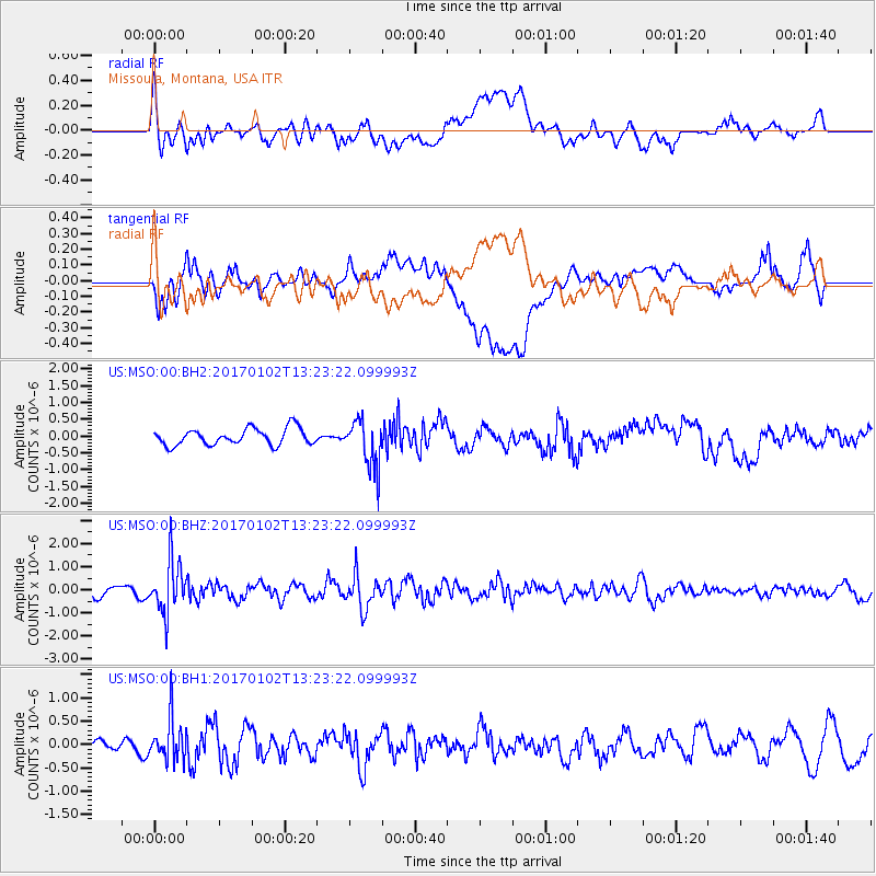
MSO Missoula, Montana, USA - Earthquake Result Viewer
*The percent match for this event was below the threshold and hence no stack was calculated.
| Earthquake location: |
Northern Peru |
| Earthquake latitude/longitude: |
-4.9/-76.3 |
| Earthquake time(UTC): |
2017/01/02 (002) 13:13:48 GMT |
| Earthquake Depth: |
108 km |
| Earthquake Magnitude: |
5.9 Mwb |
| Earthquake Catalog/Contributor: |
NEIC PDE/us |
|
| Network: |
US United States National Seismic Network |
| Station: |
MSO Missoula, Montana, USA |
| Lat/Lon: |
46.83 N/113.94 W |
| Elevation: |
1264 m |
|
| Distance: |
61.3 deg |
| Az: |
331.465 deg |
| Baz: |
136.114 deg |
| Ray Param: |
$rayparam |
*The percent match for this event was below the threshold and hence was not used in the summary stack. |
|
| Radial Match: |
73.42726 % |
| Radial Bump: |
400 |
| Transverse Match: |
66.0803 % |
| Transverse Bump: |
400 |
| SOD ConfigId: |
1943534 |
| Insert Time: |
2017-01-16 13:18:54.854 +0000 |
| GWidth: |
2.5 |
| Max Bumps: |
400 |
| Tol: |
0.001 |
|
Signal To Noise
| Channel | StoN | STA | LTA |
| US:MSO:00:BHZ:20170102T13:23:22.099993Z | 4.431346 | 1.120392E-6 | 2.5283333E-7 |
| US:MSO:00:BH1:20170102T13:23:22.099993Z | 2.9661338 | 4.507458E-7 | 1.5196409E-7 |
| US:MSO:00:BH2:20170102T13:23:22.099993Z | 2.9498227 | 7.2149334E-7 | 2.445887E-7 |
| Arrivals |
| Ps | |
| PpPs | |
| PsPs/PpSs | |


