You are here: Home > Network List > TA - USArray Transportable Network (new EarthScope stations) Stations List
> Station B10A Chitwood Farm, Usk, WA, USA > Earthquake Result Viewer
B10A Chitwood Farm, Usk, WA, USA - Earthquake Result Viewer

| Earthquake location: |
Northern Chile |
| Earthquake latitude/longitude: |
-22.2/-69.9 |
| Earthquake time(UTC): |
2007/11/14 (318) 15:40:50 GMT |
| Earthquake Depth: |
40 km |
| Earthquake Magnitude: |
6.7 MB, 7.4 MS, 7.7 MW, 7.4 ME |
| Earthquake Catalog/Contributor: |
WHDF/NEIC |
|
| Network: |
TA USArray Transportable Network (new EarthScope stations) |
| Station: |
B10A Chitwood Farm, Usk, WA, USA |
| Lat/Lon: |
48.30 N/117.23 W |
| Elevation: |
585 m |
|
| Distance: |
82.0 deg |
| Az: |
330.277 deg |
| Baz: |
136.534 deg |
| Ray Param: |
0.047123782 |
| Estimated Moho Depth: |
27.0 km |
| Estimated Crust Vp/Vs: |
1.98 |
| Assumed Crust Vp: |
6.571 km/s |
| Estimated Crust Vs: |
3.323 km/s |
| Estimated Crust Poisson's Ratio: |
0.33 |
|
| Radial Match: |
91.3731 % |
| Radial Bump: |
400 |
| Transverse Match: |
78.709206 % |
| Transverse Bump: |
400 |
| SOD ConfigId: |
2564 |
| Insert Time: |
2010-03-07 03:07:18.245 +0000 |
| GWidth: |
2.5 |
| Max Bumps: |
400 |
| Tol: |
0.001 |
|
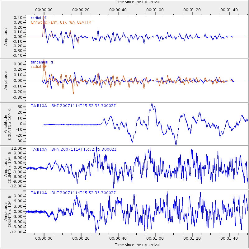
Signal To Noise
| Channel | StoN | STA | LTA |
| TA:B10A: :BHN:20071114T15:52:35.30002Z | 3.425478 | 1.2748147E-6 | 3.7215673E-7 |
| TA:B10A: :BHE:20071114T15:52:35.30002Z | 3.4704597 | 1.3072503E-6 | 3.7667928E-7 |
| TA:B10A: :BHZ:20071114T15:52:35.30002Z | 18.714123 | 4.4828444E-6 | 2.3954337E-7 |
| Arrivals |
| Ps | 4.1 SECOND |
| PpPs | 12 SECOND |
| PsPs/PpSs | 16 SECOND |


