You are here: Home > Network List > TA - USArray Transportable Network (new EarthScope stations) Stations List
> Station B10A Chitwood Farm, Usk, WA, USA > Earthquake Result Viewer
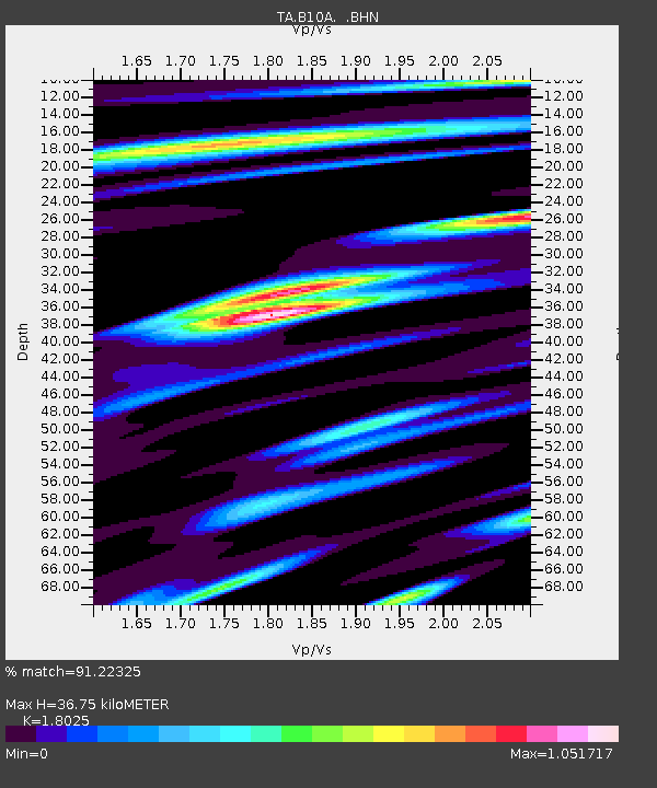
B10A Chitwood Farm, Usk, WA, USA - Earthquake Result Viewer
| Earthquake location: |
Solomon Islands |
| Earthquake latitude/longitude: |
-9.8/159.5 |
| Earthquake time(UTC): |
2007/08/16 (228) 08:39:27 GMT |
| Earthquake Depth: |
10 km |
| Earthquake Magnitude: |
6.1 MB, 6.7 MS, 6.4 MW |
| Earthquake Catalog/Contributor: |
WHDF/NEIC |
|
| Network: |
TA USArray Transportable Network (new EarthScope stations) |
| Station: |
B10A Chitwood Farm, Usk, WA, USA |
| Lat/Lon: |
48.30 N/117.23 W |
| Elevation: |
585 m |
|
| Distance: |
92.8 deg |
| Az: |
41.605 deg |
| Baz: |
258.522 deg |
| Ray Param: |
0.04137864 |
| Estimated Moho Depth: |
36.75 km |
| Estimated Crust Vp/Vs: |
1.80 |
| Assumed Crust Vp: |
6.571 km/s |
| Estimated Crust Vs: |
3.645 km/s |
| Estimated Crust Poisson's Ratio: |
0.28 |
|
| Radial Match: |
91.22325 % |
| Radial Bump: |
400 |
| Transverse Match: |
80.59574 % |
| Transverse Bump: |
400 |
| SOD ConfigId: |
2564 |
| Insert Time: |
2010-03-07 03:07:26.982 +0000 |
| GWidth: |
2.5 |
| Max Bumps: |
400 |
| Tol: |
0.001 |
|

Signal To Noise
| Channel | StoN | STA | LTA |
| TA:B10A: :BHN:20070816T08:52:08.750015Z | 1.1154534 | 1.5181698E-7 | 1.3610337E-7 |
| TA:B10A: :BHE:20070816T08:52:08.750015Z | 1.3776047 | 1.7532108E-7 | 1.2726515E-7 |
| TA:B10A: :BHZ:20070816T08:52:08.750015Z | 3.4836154 | 3.1601834E-7 | 9.071562E-8 |
| Arrivals |
| Ps | 4.6 SECOND |
| PpPs | 15 SECOND |
| PsPs/PpSs | 20 SECOND |


