You are here: Home > Network List > TA - USArray Transportable Network (new EarthScope stations) Stations List
> Station B10A Chitwood Farm, Usk, WA, USA > Earthquake Result Viewer
B10A Chitwood Farm, Usk, WA, USA - Earthquake Result Viewer
| Earthquake location: |
Andreanof Islands, Aleutian Is. |
| Earthquake latitude/longitude: |
51.3/-180.0 |
| Earthquake time(UTC): |
2007/08/02 (214) 03:21:42 GMT |
| Earthquake Depth: |
21 km |
| Earthquake Magnitude: |
6.3 MB, 6.6 MS, 6.7 MW, 6.6 MW |
| Earthquake Catalog/Contributor: |
WHDF/NEIC |
|
| Network: |
TA USArray Transportable Network (new EarthScope stations) |
| Station: |
B10A Chitwood Farm, Usk, WA, USA |
| Lat/Lon: |
48.30 N/117.23 W |
| Elevation: |
585 m |
|
| Distance: |
39.5 deg |
| Az: |
68.884 deg |
| Baz: |
298.724 deg |
| Ray Param: |
0.07490989 |
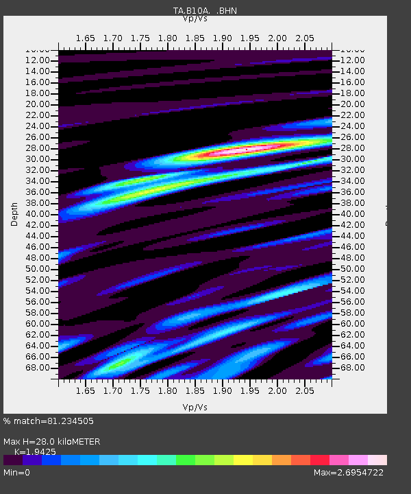
| Estimated Moho Depth: |
28.0 km |
| Estimated Crust Vp/Vs: |
1.94 |
| Assumed Crust Vp: |
6.571 km/s |
| Estimated Crust Vs: |
3.383 km/s |
| Estimated Crust Poisson's Ratio: |
0.32 |
|
| Radial Match: |
81.234505 % |
| Radial Bump: |
400 |
| Transverse Match: |
73.52307 % |
| Transverse Bump: |
400 |
| SOD ConfigId: |
2564 |
| Insert Time: |
2010-03-07 03:07:30.755 +0000 |
| GWidth: |
2.5 |
| Max Bumps: |
400 |
| Tol: |
0.001 |
|
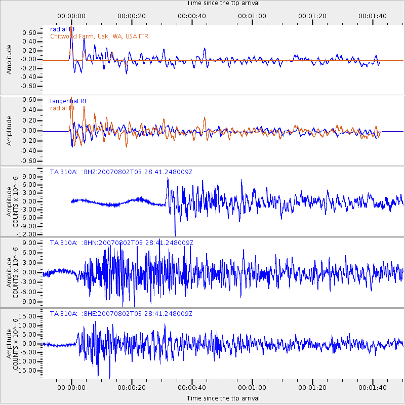
Signal To Noise
| Channel | StoN | STA | LTA |
| TA:B10A: :BHN:20070802T03:28:41.248009Z | 2.103121 | 1.2382487E-6 | 5.8876725E-7 |
| TA:B10A: :BHE:20070802T03:28:41.248009Z | 7.342233 | 3.7632092E-6 | 5.1254284E-7 |
| TA:B10A: :BHZ:20070802T03:28:41.248009Z | 5.3349013 | 3.8725784E-6 | 7.25895E-7 |
| Arrivals |
| Ps | 4.3 SECOND |
| PpPs | 12 SECOND |
| PsPs/PpSs | 16 SECOND |


