You are here: Home > Network List > TA - USArray Transportable Network (new EarthScope stations) Stations List
> Station B10A Chitwood Farm, Usk, WA, USA > Earthquake Result Viewer
B10A Chitwood Farm, Usk, WA, USA - Earthquake Result Viewer
| Earthquake location: |
Solomon Islands |
| Earthquake latitude/longitude: |
-8.5/157.0 |
| Earthquake time(UTC): |
2007/04/01 (091) 20:39:56 GMT |
| Earthquake Depth: |
10 km |
| Earthquake Magnitude: |
6.8 MB, 7.9 MS, 8.1 MW, 7.7 ME |
| Earthquake Catalog/Contributor: |
WHDF/NEIC |
|
| Network: |
TA USArray Transportable Network (new EarthScope stations) |
| Station: |
B10A Chitwood Farm, Usk, WA, USA |
| Lat/Lon: |
48.30 N/117.23 W |
| Elevation: |
585 m |
|
| Distance: |
93.4 deg |
| Az: |
41.84 deg |
| Baz: |
261.218 deg |
| Ray Param: |
0.041264616 |
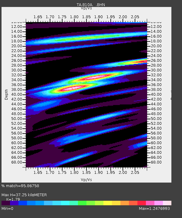
| Estimated Moho Depth: |
37.25 km |
| Estimated Crust Vp/Vs: |
1.79 |
| Assumed Crust Vp: |
6.571 km/s |
| Estimated Crust Vs: |
3.671 km/s |
| Estimated Crust Poisson's Ratio: |
0.27 |
|
| Radial Match: |
95.86758 % |
| Radial Bump: |
400 |
| Transverse Match: |
88.75706 % |
| Transverse Bump: |
400 |
| SOD ConfigId: |
2564 |
| Insert Time: |
2010-03-07 03:07:43.670 +0000 |
| GWidth: |
2.5 |
| Max Bumps: |
400 |
| Tol: |
0.001 |
|
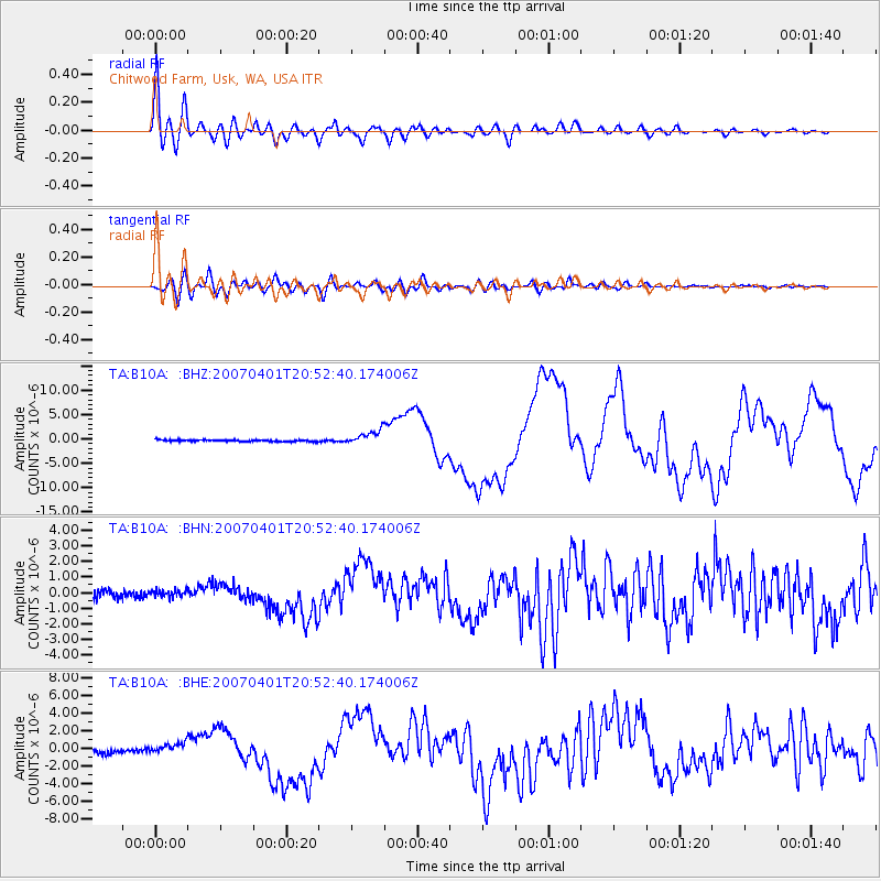
Signal To Noise
| Channel | StoN | STA | LTA |
| TA:B10A: :BHN:20070401T20:52:40.174006Z | 0.9931626 | 2.3509025E-7 | 2.3670874E-7 |
| TA:B10A: :BHE:20070401T20:52:40.174006Z | 2.7725143 | 7.0714145E-7 | 2.550542E-7 |
| TA:B10A: :BHZ:20070401T20:52:40.174006Z | 8.765053 | 1.4614748E-6 | 1.6673884E-7 |
| Arrivals |
| Ps | 4.6 SECOND |
| PpPs | 15 SECOND |
| PsPs/PpSs | 20 SECOND |


