You are here: Home > Network List > TA - USArray Transportable Network (new EarthScope stations) Stations List
> Station B10A Chitwood Farm, Usk, WA, USA > Earthquake Result Viewer
B10A Chitwood Farm, Usk, WA, USA - Earthquake Result Viewer
| Earthquake location: |
Samoa Islands Region |
| Earthquake latitude/longitude: |
-16.6/-172.0 |
| Earthquake time(UTC): |
2006/09/28 (271) 06:22:09 GMT |
| Earthquake Depth: |
28 km |
| Earthquake Magnitude: |
6.5 MB, 6.6 MS, 6.9 MW, 6.7 MW |
| Earthquake Catalog/Contributor: |
WHDF/NEIC |
|
| Network: |
TA USArray Transportable Network (new EarthScope stations) |
| Station: |
B10A Chitwood Farm, Usk, WA, USA |
| Lat/Lon: |
48.30 N/117.23 W |
| Elevation: |
585 m |
|
| Distance: |
80.9 deg |
| Az: |
33.545 deg |
| Baz: |
232.519 deg |
| Ray Param: |
0.047912605 |
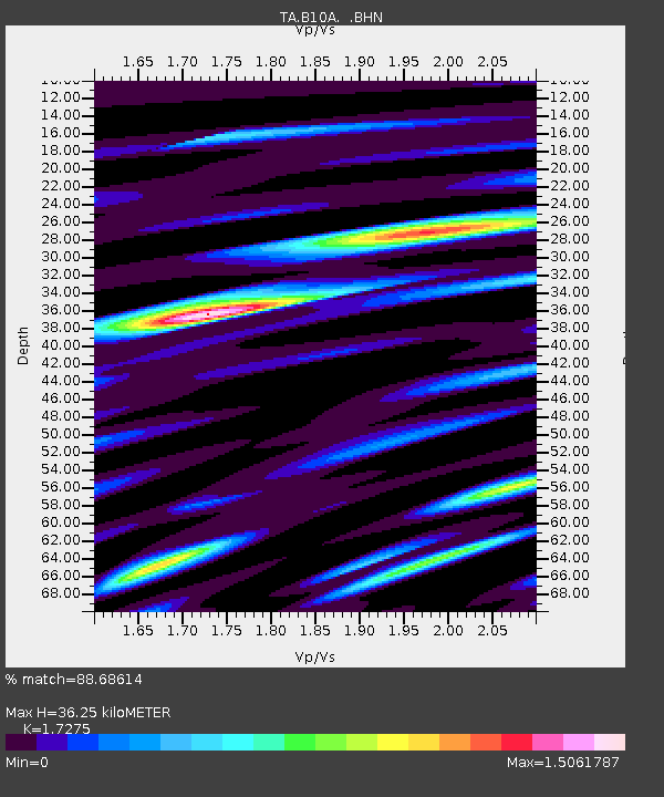
| Estimated Moho Depth: |
36.25 km |
| Estimated Crust Vp/Vs: |
1.73 |
| Assumed Crust Vp: |
6.571 km/s |
| Estimated Crust Vs: |
3.804 km/s |
| Estimated Crust Poisson's Ratio: |
0.25 |
|
| Radial Match: |
88.68614 % |
| Radial Bump: |
400 |
| Transverse Match: |
82.88804 % |
| Transverse Bump: |
400 |
| SOD ConfigId: |
2665 |
| Insert Time: |
2010-03-07 03:07:53.673 +0000 |
| GWidth: |
2.5 |
| Max Bumps: |
400 |
| Tol: |
0.001 |
|

Signal To Noise
| Channel | StoN | STA | LTA |
| TA:B10A: :BHN:20060928T06:33:50.149006Z | 6.0095572 | 9.1288683E-7 | 1.5190584E-7 |
| TA:B10A: :BHE:20060928T06:33:50.149006Z | 8.250693 | 1.1616795E-6 | 1.4079781E-7 |
| TA:B10A: :BHZ:20060928T06:33:50.149006Z | 22.75024 | 3.3489061E-6 | 1.4720311E-7 |
| Arrivals |
| Ps | 4.1 SECOND |
| PpPs | 15 SECOND |
| PsPs/PpSs | 19 SECOND |


