You are here: Home > Network List > TS - TERRAscope (Southern California Seismic Network) Stations List
> Station MLAC Mammoth Lakes, California, USA > Earthquake Result Viewer
MLAC Mammoth Lakes, California, USA - Earthquake Result Viewer

| Earthquake location: |
South Pacific Ocean |
| Earthquake latitude/longitude: |
-10.8/-128.8 |
| Earthquake time(UTC): |
1994/02/12 (043) 04:16:26 GMT |
| Earthquake Depth: |
10 km |
| Earthquake Magnitude: |
6.3 MB, 6.5 MS, 6.6 UNKNOWN, 6.6 MW |
| Earthquake Catalog/Contributor: |
WHDF/NEIC |
|
| Network: |
TS TERRAscope (Southern California Seismic Network) |
| Station: |
MLAC Mammoth Lakes, California, USA |
| Lat/Lon: |
37.63 N/118.83 W |
| Elevation: |
2170 m |
|
| Distance: |
49.1 deg |
| Az: |
10.509 deg |
| Baz: |
193.046 deg |
| Ray Param: |
0.06894919 |
| Estimated Moho Depth: |
34.0 km |
| Estimated Crust Vp/Vs: |
1.82 |
| Assumed Crust Vp: |
6.291 km/s |
| Estimated Crust Vs: |
3.466 km/s |
| Estimated Crust Poisson's Ratio: |
0.28 |
|
| Radial Match: |
85.40987 % |
| Radial Bump: |
400 |
| Transverse Match: |
75.42715 % |
| Transverse Bump: |
400 |
| SOD ConfigId: |
16938 |
| Insert Time: |
2010-02-26 14:25:02.018 +0000 |
| GWidth: |
2.5 |
| Max Bumps: |
400 |
| Tol: |
0.001 |
|
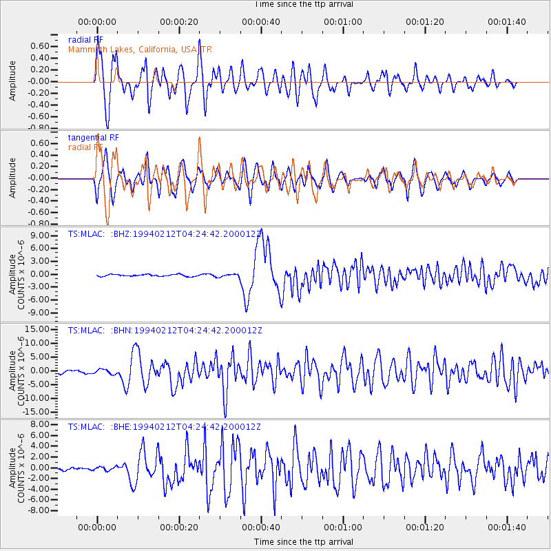
Signal To Noise
| Channel | StoN | STA | LTA |
| TS:MLAC: :BHN:19940212T04:24:42.200012Z | 1.6807265 | 8.7300305E-7 | 5.1942004E-7 |
| TS:MLAC: :BHE:19940212T04:24:42.200012Z | 0.876087 | 3.464781E-7 | 3.9548365E-7 |
| TS:MLAC: :BHZ:19940212T04:24:42.200012Z | 1.593105 | 3.468115E-7 | 2.1769533E-7 |
| Arrivals |
| Ps | 4.7 SECOND |
| PpPs | 14 SECOND |
| PsPs/PpSs | 19 SECOND |


