You are here: Home > Network List > TA - USArray Transportable Network (new EarthScope stations) Stations List
> Station E10A Myers Farm, Uniontown, WA, USA > Earthquake Result Viewer
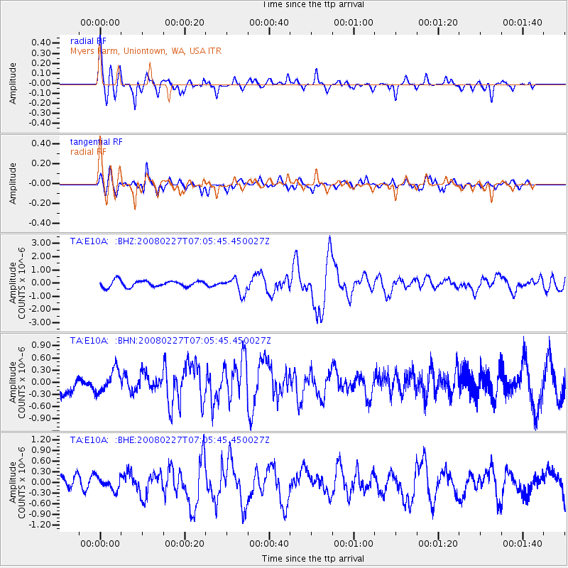
E10A Myers Farm, Uniontown, WA, USA - Earthquake Result Viewer
| Earthquake location: |
Bonin Islands, Japan Region |
| Earthquake latitude/longitude: |
26.8/142.4 |
| Earthquake time(UTC): |
2008/02/27 (058) 06:54:20 GMT |
| Earthquake Depth: |
15 km |
| Earthquake Magnitude: |
5.8 MB, 6.1 MS, 6.2 MW, 6.2 MW |
| Earthquake Catalog/Contributor: |
WHDF/NEIC |
|
| Network: |
TA USArray Transportable Network (new EarthScope stations) |
| Station: |
E10A Myers Farm, Uniontown, WA, USA |
| Lat/Lon: |
46.49 N/117.11 W |
| Elevation: |
903 m |
|
| Distance: |
77.7 deg |
| Az: |
44.056 deg |
| Baz: |
295.926 deg |
| Ray Param: |
0.050107606 |
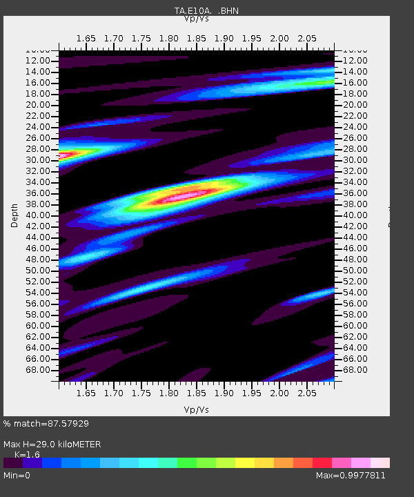
| Estimated Moho Depth: |
29.0 km |
| Estimated Crust Vp/Vs: |
1.60 |
| Assumed Crust Vp: |
6.571 km/s |
| Estimated Crust Vs: |
4.107 km/s |
| Estimated Crust Poisson's Ratio: |
0.18 |
|
| Radial Match: |
87.57929 % |
| Radial Bump: |
400 |
| Transverse Match: |
80.766335 % |
| Transverse Bump: |
400 |
| SOD ConfigId: |
2564 |
| Insert Time: |
2010-03-07 03:08:24.776 +0000 |
| GWidth: |
2.5 |
| Max Bumps: |
400 |
| Tol: |
0.001 |
|
Signal To Noise
| Channel | StoN | STA | LTA |
| TA:E10A: :BHN:20080227T07:05:45.450027Z | 1.4952682 | 2.7643947E-7 | 1.8487617E-7 |
| TA:E10A: :BHE:20080227T07:05:45.450027Z | 0.79772085 | 1.7356702E-7 | 2.1757863E-7 |
| TA:E10A: :BHZ:20080227T07:05:45.450027Z | 2.5626688 | 6.1052754E-7 | 2.3823897E-7 |
| Arrivals |
| Ps | 2.7 SECOND |
| PpPs | 11 SECOND |
| PsPs/PpSs | 14 SECOND |


