You are here: Home > Network List > TA - USArray Transportable Network (new EarthScope stations) Stations List
> Station E10A Myers Farm, Uniontown, WA, USA > Earthquake Result Viewer
E10A Myers Farm, Uniontown, WA, USA - Earthquake Result Viewer
| Earthquake location: |
Near West Coast Of Colombia |
| Earthquake latitude/longitude: |
3.0/-78.0 |
| Earthquake time(UTC): |
2007/09/10 (253) 01:49:14 GMT |
| Earthquake Depth: |
31 km |
| Earthquake Magnitude: |
6.1 MB, 6.7 MS, 6.8 MW |
| Earthquake Catalog/Contributor: |
WHDF/NEIC |
|
| Network: |
TA USArray Transportable Network (new EarthScope stations) |
| Station: |
E10A Myers Farm, Uniontown, WA, USA |
| Lat/Lon: |
46.49 N/117.11 W |
| Elevation: |
903 m |
|
| Distance: |
55.1 deg |
| Az: |
327.859 deg |
| Baz: |
129.743 deg |
| Ray Param: |
0.06497983 |
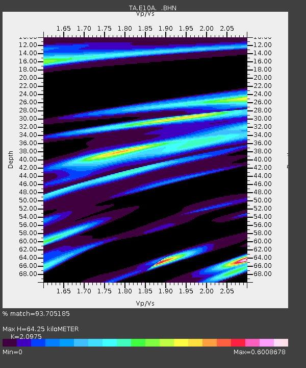
| Estimated Moho Depth: |
64.25 km |
| Estimated Crust Vp/Vs: |
2.10 |
| Assumed Crust Vp: |
6.571 km/s |
| Estimated Crust Vs: |
3.133 km/s |
| Estimated Crust Poisson's Ratio: |
0.35 |
|
| Radial Match: |
93.705185 % |
| Radial Bump: |
400 |
| Transverse Match: |
80.89955 % |
| Transverse Bump: |
400 |
| SOD ConfigId: |
2564 |
| Insert Time: |
2010-03-07 03:08:48.049 +0000 |
| GWidth: |
2.5 |
| Max Bumps: |
400 |
| Tol: |
0.001 |
|
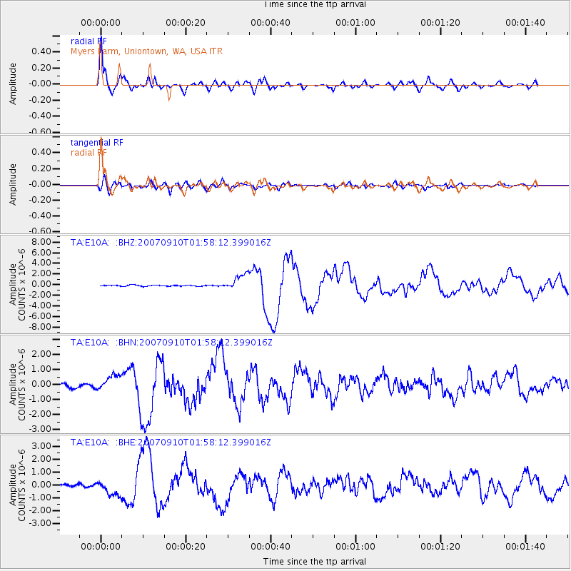
Signal To Noise
| Channel | StoN | STA | LTA |
| TA:E10A: :BHN:20070910T01:58:12.399016Z | 4.0724926 | 5.1815687E-7 | 1.2723335E-7 |
| TA:E10A: :BHE:20070910T01:58:12.399016Z | 6.0789146 | 6.045449E-7 | 9.944948E-8 |
| TA:E10A: :BHZ:20070910T01:58:12.399016Z | 15.284404 | 1.5520893E-6 | 1.01547265E-7 |
| Arrivals |
| Ps | 11 SECOND |
| PpPs | 29 SECOND |
| PsPs/PpSs | 40 SECOND |


