You are here: Home > Network List > TS - TERRAscope (Southern California Seismic Network) Stations List
> Station MLAC Mammoth Lakes, California, USA > Earthquake Result Viewer
MLAC Mammoth Lakes, California, USA - Earthquake Result Viewer
| Earthquake location: |
Southern Peru |
| Earthquake latitude/longitude: |
-15.2/-70.3 |
| Earthquake time(UTC): |
1994/06/16 (167) 18:41:31 GMT |
| Earthquake Depth: |
225 km |
| Earthquake Magnitude: |
5.6 MB, 5.8 UNKNOWN, 6.1 MW |
| Earthquake Catalog/Contributor: |
WHDF/NEIC |
|
| Network: |
TS TERRAscope (Southern California Seismic Network) |
| Station: |
MLAC Mammoth Lakes, California, USA |
| Lat/Lon: |
37.63 N/118.83 W |
| Elevation: |
2170 m |
|
| Distance: |
69.5 deg |
| Az: |
320.608 deg |
| Baz: |
129.484 deg |
| Ray Param: |
0.054941535 |
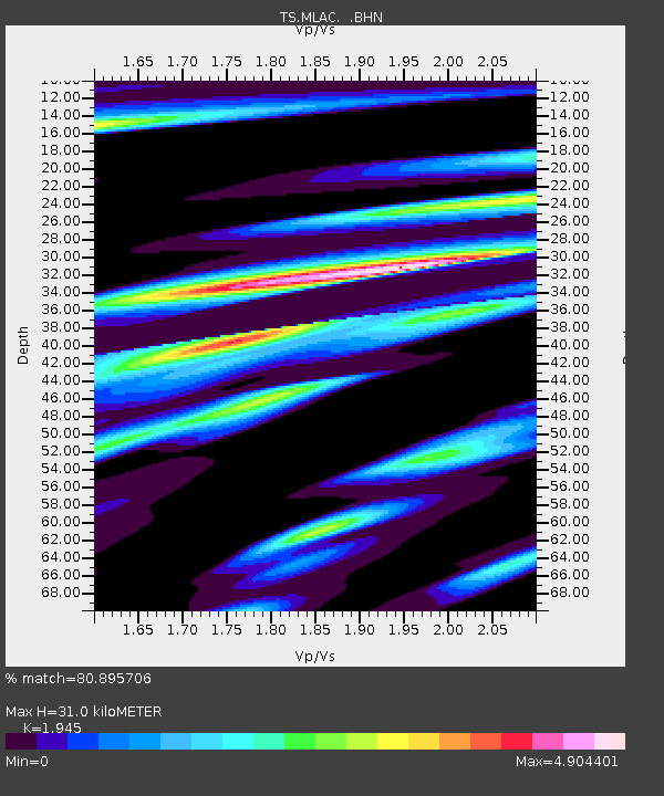
| Estimated Moho Depth: |
31.0 km |
| Estimated Crust Vp/Vs: |
1.95 |
| Assumed Crust Vp: |
6.291 km/s |
| Estimated Crust Vs: |
3.235 km/s |
| Estimated Crust Poisson's Ratio: |
0.32 |
|
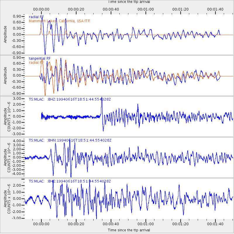
| Radial Match: |
80.895706 % |
| Radial Bump: |
400 |
| Transverse Match: |
71.93155 % |
| Transverse Bump: |
400 |
| SOD ConfigId: |
16938 |
| Insert Time: |
2010-02-26 14:25:04.322 +0000 |
| GWidth: |
2.5 |
| Max Bumps: |
400 |
| Tol: |
0.001 |
|
Signal To Noise
| Channel | StoN | STA | LTA |
| TS:MLAC: :BHN:19940616T18:51:44.554028Z | 0.71275747 | 2.1550855E-7 | 3.0235887E-7 |
| TS:MLAC: :BHE:19940616T18:51:44.554028Z | 1.3628799 | 4.6993418E-7 | 3.448097E-7 |
| TS:MLAC: :BHZ:19940616T18:51:44.554028Z | 4.5802755 | 8.519892E-7 | 1.8601266E-7 |
| Arrivals |
| Ps | 4.8 SECOND |
| PpPs | 14 SECOND |
| PsPs/PpSs | 19 SECOND |


