You are here: Home > Network List > TA - USArray Transportable Network (new EarthScope stations) Stations List
> Station E10A Myers Farm, Uniontown, WA, USA > Earthquake Result Viewer
E10A Myers Farm, Uniontown, WA, USA - Earthquake Result Viewer
| Earthquake location: |
Vanuatu Islands |
| Earthquake latitude/longitude: |
-15.4/168.6 |
| Earthquake time(UTC): |
2007/07/15 (196) 09:27:34 GMT |
| Earthquake Depth: |
8.0 km |
| Earthquake Magnitude: |
6.0 MB, 5.8 MS, 6.1 MW, 6.0 MW |
| Earthquake Catalog/Contributor: |
WHDF/NEIC |
|
| Network: |
TA USArray Transportable Network (new EarthScope stations) |
| Station: |
E10A Myers Farm, Uniontown, WA, USA |
| Lat/Lon: |
46.49 N/117.11 W |
| Elevation: |
903 m |
|
| Distance: |
90.6 deg |
| Az: |
41.698 deg |
| Baz: |
248.226 deg |
| Ray Param: |
0.041663576 |
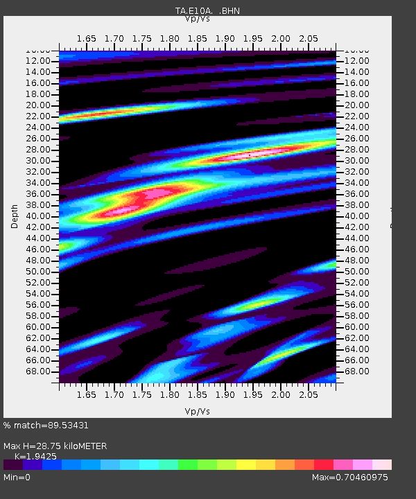
| Estimated Moho Depth: |
28.75 km |
| Estimated Crust Vp/Vs: |
1.94 |
| Assumed Crust Vp: |
6.571 km/s |
| Estimated Crust Vs: |
3.383 km/s |
| Estimated Crust Poisson's Ratio: |
0.32 |
|
| Radial Match: |
89.53431 % |
| Radial Bump: |
400 |
| Transverse Match: |
82.56991 % |
| Transverse Bump: |
400 |
| SOD ConfigId: |
2564 |
| Insert Time: |
2010-03-07 03:09:04.994 +0000 |
| GWidth: |
2.5 |
| Max Bumps: |
400 |
| Tol: |
0.001 |
|
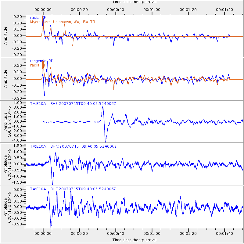
Signal To Noise
| Channel | StoN | STA | LTA |
| TA:E10A: :BHN:20070715T09:40:05.524006Z | 6.6691866 | 3.372828E-7 | 5.0573306E-8 |
| TA:E10A: :BHE:20070715T09:40:05.524006Z | 8.273943 | 4.6265967E-7 | 5.5917678E-8 |
| TA:E10A: :BHZ:20070715T09:40:05.524006Z | 31.942986 | 1.938411E-6 | 6.068347E-8 |
| Arrivals |
| Ps | 4.2 SECOND |
| PpPs | 13 SECOND |
| PsPs/PpSs | 17 SECOND |


