You are here: Home > Network List > TA - USArray Transportable Network (new EarthScope stations) Stations List
> Station E10A Myers Farm, Uniontown, WA, USA > Earthquake Result Viewer
E10A Myers Farm, Uniontown, WA, USA - Earthquake Result Viewer
| Earthquake location: |
Kuril Islands |
| Earthquake latitude/longitude: |
46.5/153.2 |
| Earthquake time(UTC): |
2006/10/01 (274) 09:06:02 GMT |
| Earthquake Depth: |
19 km |
| Earthquake Magnitude: |
6.1 MB, 6.4 MS, 6.6 MW, 6.5 MW |
| Earthquake Catalog/Contributor: |
WHDF/NEIC |
|
| Network: |
TA USArray Transportable Network (new EarthScope stations) |
| Station: |
E10A Myers Farm, Uniontown, WA, USA |
| Lat/Lon: |
46.49 N/117.11 W |
| Elevation: |
903 m |
|
| Distance: |
58.3 deg |
| Az: |
54.296 deg |
| Baz: |
305.682 deg |
| Ray Param: |
0.06290804 |
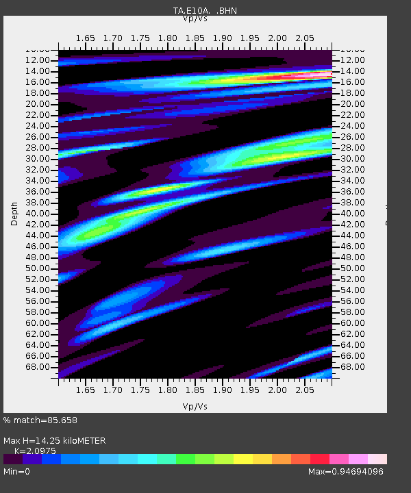
| Estimated Moho Depth: |
14.25 km |
| Estimated Crust Vp/Vs: |
2.10 |
| Assumed Crust Vp: |
6.571 km/s |
| Estimated Crust Vs: |
3.133 km/s |
| Estimated Crust Poisson's Ratio: |
0.35 |
|
| Radial Match: |
85.658 % |
| Radial Bump: |
400 |
| Transverse Match: |
82.55556 % |
| Transverse Bump: |
400 |
| SOD ConfigId: |
2564 |
| Insert Time: |
2010-03-07 03:09:13.054 +0000 |
| GWidth: |
2.5 |
| Max Bumps: |
400 |
| Tol: |
0.001 |
|
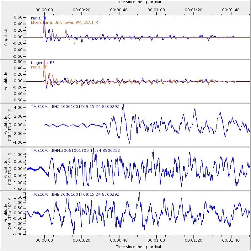
Signal To Noise
| Channel | StoN | STA | LTA |
| TA:E10A: :BHN:20061001T09:15:24.850029Z | 2.754456 | 4.142268E-7 | 1.5038425E-7 |
| TA:E10A: :BHE:20061001T09:15:24.850029Z | 2.3555212 | 4.657856E-7 | 1.9774204E-7 |
| TA:E10A: :BHZ:20061001T09:15:24.850029Z | 4.086827 | 7.8748945E-7 | 1.9268971E-7 |
| Arrivals |
| Ps | 2.5 SECOND |
| PpPs | 6.4 SECOND |
| PsPs/PpSs | 8.9 SECOND |


