You are here: Home > Network List > TA - USArray Transportable Network (new EarthScope stations) Stations List
> Station E10A Myers Farm, Uniontown, WA, USA > Earthquake Result Viewer
E10A Myers Farm, Uniontown, WA, USA - Earthquake Result Viewer
| Earthquake location: |
Chile-Argentina Border Region |
| Earthquake latitude/longitude: |
-24.2/-67.0 |
| Earthquake time(UTC): |
2007/05/25 (145) 17:47:31 GMT |
| Earthquake Depth: |
180 km |
| Earthquake Magnitude: |
5.5 MB, 5.9 MW, 5.9 MW |
| Earthquake Catalog/Contributor: |
WHDF/NEIC |
|
| Network: |
TA USArray Transportable Network (new EarthScope stations) |
| Station: |
E10A Myers Farm, Uniontown, WA, USA |
| Lat/Lon: |
46.49 N/117.11 W |
| Elevation: |
903 m |
|
| Distance: |
83.7 deg |
| Az: |
327.779 deg |
| Baz: |
135.21 deg |
| Ray Param: |
0.045583803 |
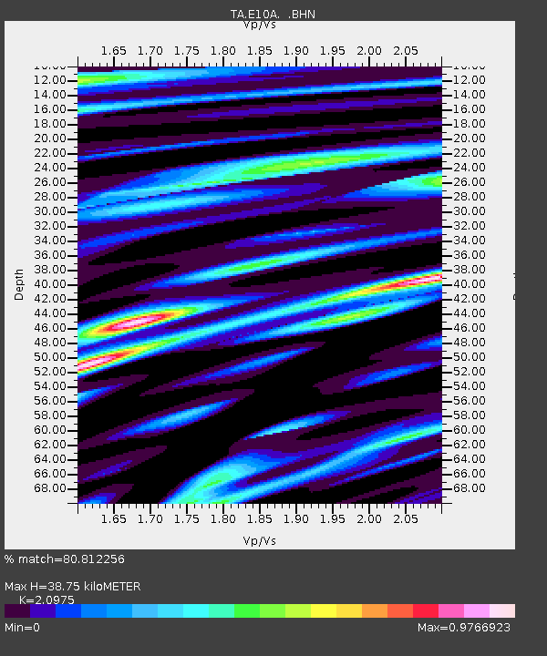
| Estimated Moho Depth: |
38.75 km |
| Estimated Crust Vp/Vs: |
2.10 |
| Assumed Crust Vp: |
6.571 km/s |
| Estimated Crust Vs: |
3.133 km/s |
| Estimated Crust Poisson's Ratio: |
0.35 |
|
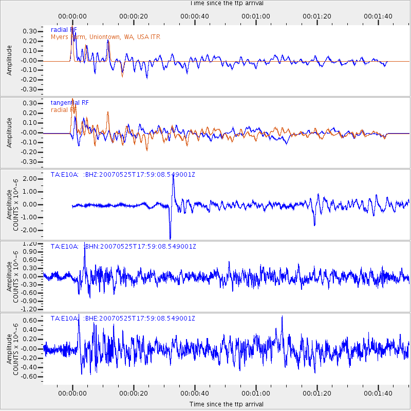
| Radial Match: |
80.812256 % |
| Radial Bump: |
400 |
| Transverse Match: |
72.41725 % |
| Transverse Bump: |
400 |
| SOD ConfigId: |
2564 |
| Insert Time: |
2010-03-07 03:09:17.672 +0000 |
| GWidth: |
2.5 |
| Max Bumps: |
400 |
| Tol: |
0.001 |
|
Signal To Noise
| Channel | StoN | STA | LTA |
| TA:E10A: :BHN:20070525T17:59:08.549001Z | 3.7513607 | 3.115177E-7 | 8.3041265E-8 |
| TA:E10A: :BHE:20070525T17:59:08.549001Z | 3.0608876 | 2.2516322E-7 | 7.356142E-8 |
| TA:E10A: :BHZ:20070525T17:59:08.549001Z | 14.433511 | 9.642516E-7 | 6.680645E-8 |
| Arrivals |
| Ps | 6.6 SECOND |
| PpPs | 18 SECOND |
| PsPs/PpSs | 24 SECOND |


