You are here: Home > Network List > TA - USArray Transportable Network (new EarthScope stations) Stations List
> Station E10A Myers Farm, Uniontown, WA, USA > Earthquake Result Viewer
E10A Myers Farm, Uniontown, WA, USA - Earthquake Result Viewer
| Earthquake location: |
Primor'ye, Russia |
| Earthquake latitude/longitude: |
43.2/133.5 |
| Earthquake time(UTC): |
2007/03/09 (068) 03:22:42 GMT |
| Earthquake Depth: |
441 km |
| Earthquake Magnitude: |
6.1 MB, 6.0 MW, 6.0 MW |
| Earthquake Catalog/Contributor: |
WHDF/NEIC |
|
| Network: |
TA USArray Transportable Network (new EarthScope stations) |
| Station: |
E10A Myers Farm, Uniontown, WA, USA |
| Lat/Lon: |
46.49 N/117.11 W |
| Elevation: |
903 m |
|
| Distance: |
71.0 deg |
| Az: |
43.592 deg |
| Baz: |
313.161 deg |
| Ray Param: |
0.05323135 |
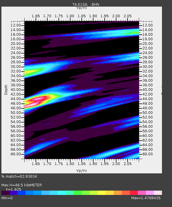
| Estimated Moho Depth: |
46.5 km |
| Estimated Crust Vp/Vs: |
1.62 |
| Assumed Crust Vp: |
6.571 km/s |
| Estimated Crust Vs: |
4.044 km/s |
| Estimated Crust Poisson's Ratio: |
0.20 |
|
| Radial Match: |
82.93834 % |
| Radial Bump: |
400 |
| Transverse Match: |
65.197 % |
| Transverse Bump: |
400 |
| SOD ConfigId: |
2564 |
| Insert Time: |
2010-03-07 03:09:26.408 +0000 |
| GWidth: |
2.5 |
| Max Bumps: |
400 |
| Tol: |
0.001 |
|
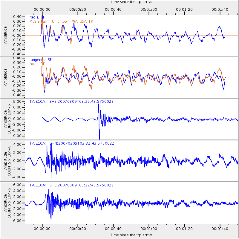
Signal To Noise
| Channel | StoN | STA | LTA |
| TA:E10A: :BHN:20070309T03:32:43.575002Z | 3.3839598 | 1.4761971E-6 | 4.3623365E-7 |
| TA:E10A: :BHE:20070309T03:32:43.575002Z | 5.5888066 | 1.8506203E-6 | 3.3112977E-7 |
| TA:E10A: :BHZ:20070309T03:32:43.575002Z | 5.272428 | 3.2839653E-6 | 6.228563E-7 |
| Arrivals |
| Ps | 4.6 SECOND |
| PpPs | 18 SECOND |
| PsPs/PpSs | 22 SECOND |


