You are here: Home > Network List > TA - USArray Transportable Network (new EarthScope stations) Stations List
> Station E10A Myers Farm, Uniontown, WA, USA > Earthquake Result Viewer
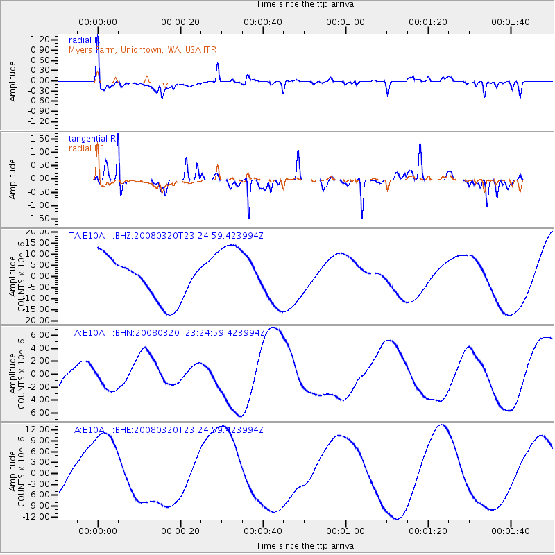
E10A Myers Farm, Uniontown, WA, USA - Earthquake Result Viewer
*The percent match for this event was below the threshold and hence no stack was calculated.
| Earthquake location: |
Southern Xinjiang, China |
| Earthquake latitude/longitude: |
35.5/81.4 |
| Earthquake time(UTC): |
2008/03/20 (080) 23:12:00 GMT |
| Earthquake Depth: |
10 km |
| Earthquake Magnitude: |
5.6 MB |
| Earthquake Catalog/Contributor: |
WHDF/NEIC |
|
| Network: |
TA USArray Transportable Network (new EarthScope stations) |
| Station: |
E10A Myers Farm, Uniontown, WA, USA |
| Lat/Lon: |
46.49 N/117.11 W |
| Elevation: |
903 m |
|
| Distance: |
96.7 deg |
| Az: |
12.782 deg |
| Baz: |
344.857 deg |
| Ray Param: |
$rayparam |
*The percent match for this event was below the threshold and hence was not used in the summary stack. |
|
| Radial Match: |
70.1654 % |
| Radial Bump: |
400 |
| Transverse Match: |
67.99102 % |
| Transverse Bump: |
277 |
| SOD ConfigId: |
2504 |
| Insert Time: |
2010-03-07 03:09:45.233 +0000 |
| GWidth: |
2.5 |
| Max Bumps: |
400 |
| Tol: |
0.001 |
|
Signal To Noise
| Channel | StoN | STA | LTA |
| TA:E10A: :BHN:20080320T23:24:59.423994Z | 0.6568779 | 1.6804488E-6 | 2.5582362E-6 |
| TA:E10A: :BHE:20080320T23:24:59.423994Z | 2.3446949 | 1.11874E-5 | 4.771367E-6 |
| TA:E10A: :BHZ:20080320T23:24:59.423994Z | 1.7359368 | 1.5711963E-5 | 9.050999E-6 |
| Arrivals |
| Ps | |
| PpPs | |
| PsPs/PpSs | |


