You are here: Home > Network List > TA - USArray Transportable Network (new EarthScope stations) Stations List
> Station E10A Myers Farm, Uniontown, WA, USA > Earthquake Result Viewer
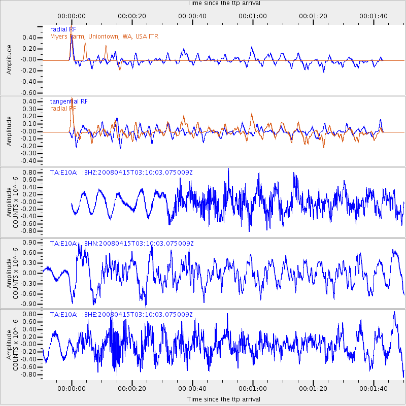
E10A Myers Farm, Uniontown, WA, USA - Earthquake Result Viewer
*The percent match for this event was below the threshold and hence no stack was calculated.
| Earthquake location: |
Near Coast Of Guatemala |
| Earthquake latitude/longitude: |
13.6/-90.6 |
| Earthquake time(UTC): |
2008/04/15 (106) 03:03:04 GMT |
| Earthquake Depth: |
33 km |
| Earthquake Magnitude: |
5.6 MB, 5.8 MS, 6.1 MW, 6.1 MW |
| Earthquake Catalog/Contributor: |
WHDF/NEIC |
|
| Network: |
TA USArray Transportable Network (new EarthScope stations) |
| Station: |
E10A Myers Farm, Uniontown, WA, USA |
| Lat/Lon: |
46.49 N/117.11 W |
| Elevation: |
903 m |
|
| Distance: |
39.7 deg |
| Az: |
331.107 deg |
| Baz: |
137.155 deg |
| Ray Param: |
$rayparam |
*The percent match for this event was below the threshold and hence was not used in the summary stack. |
|
| Radial Match: |
66.561676 % |
| Radial Bump: |
400 |
| Transverse Match: |
59.5803 % |
| Transverse Bump: |
400 |
| SOD ConfigId: |
2504 |
| Insert Time: |
2010-03-07 03:09:49.847 +0000 |
| GWidth: |
2.5 |
| Max Bumps: |
400 |
| Tol: |
0.001 |
|
Signal To Noise
| Channel | StoN | STA | LTA |
| TA:E10A: :BHN:20080415T03:10:03.075009Z | 2.4185617 | 5.50709E-7 | 2.2770102E-7 |
| TA:E10A: :BHE:20080415T03:10:03.075009Z | 0.8016576 | 1.6809251E-7 | 2.0968118E-7 |
| TA:E10A: :BHZ:20080415T03:10:03.075009Z | 1.3593572 | 2.90939E-7 | 2.140269E-7 |
| Arrivals |
| Ps | |
| PpPs | |
| PsPs/PpSs | |


