You are here: Home > Network List > TA - USArray Transportable Network (new EarthScope stations) Stations List
> Station E10A Myers Farm, Uniontown, WA, USA > Earthquake Result Viewer
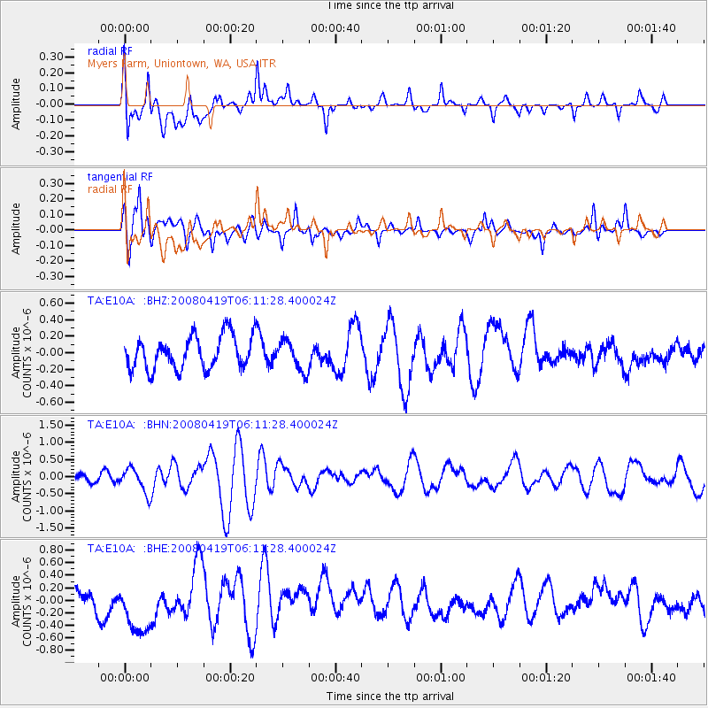
E10A Myers Farm, Uniontown, WA, USA - Earthquake Result Viewer
*The percent match for this event was below the threshold and hence no stack was calculated.
| Earthquake location: |
Loyalty Islands |
| Earthquake latitude/longitude: |
-20.3/168.8 |
| Earthquake time(UTC): |
2008/04/19 (110) 05:58:42 GMT |
| Earthquake Depth: |
14 km |
| Earthquake Magnitude: |
5.7 MB, 6.2 MS, 6.3 MW, 6.2 MW |
| Earthquake Catalog/Contributor: |
WHDF/NEIC |
|
| Network: |
TA USArray Transportable Network (new EarthScope stations) |
| Station: |
E10A Myers Farm, Uniontown, WA, USA |
| Lat/Lon: |
46.49 N/117.11 W |
| Elevation: |
903 m |
|
| Distance: |
94.1 deg |
| Az: |
41.775 deg |
| Baz: |
244.845 deg |
| Ray Param: |
$rayparam |
*The percent match for this event was below the threshold and hence was not used in the summary stack. |
|
| Radial Match: |
60.22786 % |
| Radial Bump: |
400 |
| Transverse Match: |
57.40745 % |
| Transverse Bump: |
390 |
| SOD ConfigId: |
2504 |
| Insert Time: |
2010-03-07 03:09:50.558 +0000 |
| GWidth: |
2.5 |
| Max Bumps: |
400 |
| Tol: |
0.001 |
|
Signal To Noise
| Channel | StoN | STA | LTA |
| TA:E10A: :BHN:20080419T06:11:28.400024Z | 2.8599062 | 3.661489E-7 | 1.2802828E-7 |
| TA:E10A: :BHE:20080419T06:11:28.400024Z | 2.286505 | 4.348579E-7 | 1.9018454E-7 |
| TA:E10A: :BHZ:20080419T06:11:28.400024Z | 0.939203 | 1.8457223E-7 | 1.9652005E-7 |
| Arrivals |
| Ps | |
| PpPs | |
| PsPs/PpSs | |


