You are here: Home > Network List > TS - TERRAscope (Southern California Seismic Network) Stations List
> Station MLAC Mammoth Lakes, California, USA > Earthquake Result Viewer
MLAC Mammoth Lakes, California, USA - Earthquake Result Viewer

| Earthquake location: |
Near Coast Of Nicaragua |
| Earthquake latitude/longitude: |
11.8/-87.9 |
| Earthquake time(UTC): |
1996/03/27 (087) 20:52:06 GMT |
| Earthquake Depth: |
33 km |
| Earthquake Magnitude: |
5.5 MB, 5.5 MS, 5.9 UNKNOWN, 5.4 MS |
| Earthquake Catalog/Contributor: |
WHDF/NEIC |
|
| Network: |
TS TERRAscope (Southern California Seismic Network) |
| Station: |
MLAC Mammoth Lakes, California, USA |
| Lat/Lon: |
37.63 N/118.83 W |
| Elevation: |
2170 m |
|
| Distance: |
37.8 deg |
| Az: |
318.276 deg |
| Baz: |
124.828 deg |
| Ray Param: |
0.075879924 |
| Estimated Moho Depth: |
37.5 km |
| Estimated Crust Vp/Vs: |
1.66 |
| Assumed Crust Vp: |
6.291 km/s |
| Estimated Crust Vs: |
3.784 km/s |
| Estimated Crust Poisson's Ratio: |
0.22 |
|
| Radial Match: |
89.18704 % |
| Radial Bump: |
387 |
| Transverse Match: |
86.31787 % |
| Transverse Bump: |
400 |
| SOD ConfigId: |
9875 |
| Insert Time: |
2010-02-26 14:25:10.037 +0000 |
| GWidth: |
2.5 |
| Max Bumps: |
400 |
| Tol: |
0.001 |
|
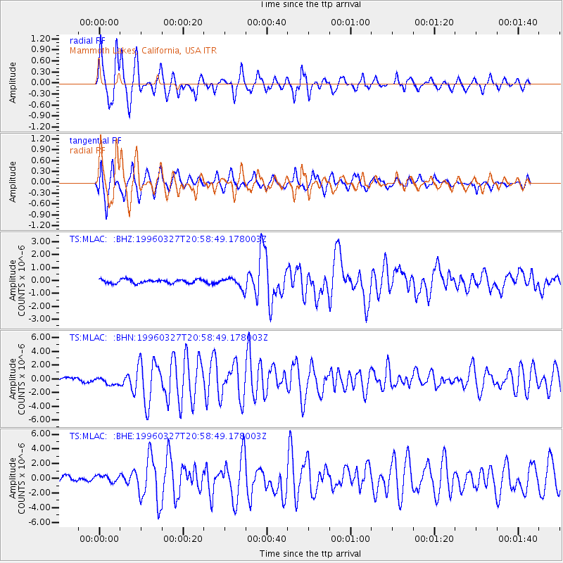
Signal To Noise
| Channel | StoN | STA | LTA |
| TS:MLAC: :BHN:19960327T20:58:49.178003Z | 2.3970535 | 7.450264E-7 | 3.1080924E-7 |
| TS:MLAC: :BHE:19960327T20:58:49.178003Z | 1.3402331 | 4.3494381E-7 | 3.245285E-7 |
| TS:MLAC: :BHZ:19960327T20:58:49.178003Z | 2.9111278 | 4.363525E-7 | 1.4989124E-7 |
| Arrivals |
| Ps | 4.3 SECOND |
| PpPs | 15 SECOND |
| PsPs/PpSs | 19 SECOND |


