You are here: Home > Network List > TA - USArray Transportable Network (new EarthScope stations) Stations List
> Station B18K Kokolik River, AK, USA > Earthquake Result Viewer
B18K Kokolik River, AK, USA - Earthquake Result Viewer
| Earthquake location: |
Turkey |
| Earthquake latitude/longitude: |
37.9/29.7 |
| Earthquake time(UTC): |
2019/08/08 (220) 11:25:31 GMT |
| Earthquake Depth: |
10 km |
| Earthquake Magnitude: |
5.8 Mww |
| Earthquake Catalog/Contributor: |
NEIC PDE/us |
|
| Network: |
TA USArray Transportable Network (new EarthScope stations) |
| Station: |
B18K Kokolik River, AK, USA |
| Lat/Lon: |
69.36 N/161.80 W |
| Elevation: |
222 m |
|
| Distance: |
72.7 deg |
| Az: |
4.246 deg |
| Baz: |
350.497 deg |
| Ray Param: |
0.053511683 |
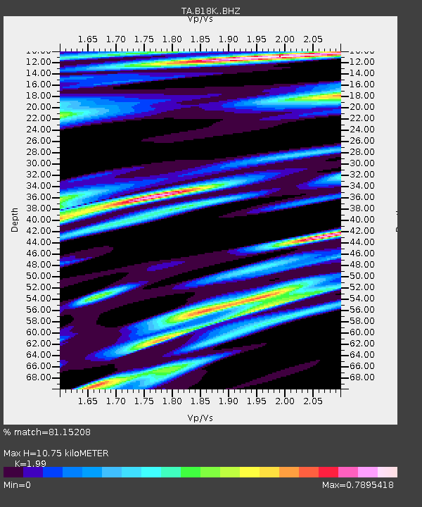
| Estimated Moho Depth: |
10.75 km |
| Estimated Crust Vp/Vs: |
1.99 |
| Assumed Crust Vp: |
5.906 km/s |
| Estimated Crust Vs: |
2.968 km/s |
| Estimated Crust Poisson's Ratio: |
0.33 |
|
| Radial Match: |
81.15208 % |
| Radial Bump: |
400 |
| Transverse Match: |
63.615505 % |
| Transverse Bump: |
390 |
| SOD ConfigId: |
19053131 |
| Insert Time: |
2019-08-22 11:36:35.731 +0000 |
| GWidth: |
2.5 |
| Max Bumps: |
400 |
| Tol: |
0.001 |
|
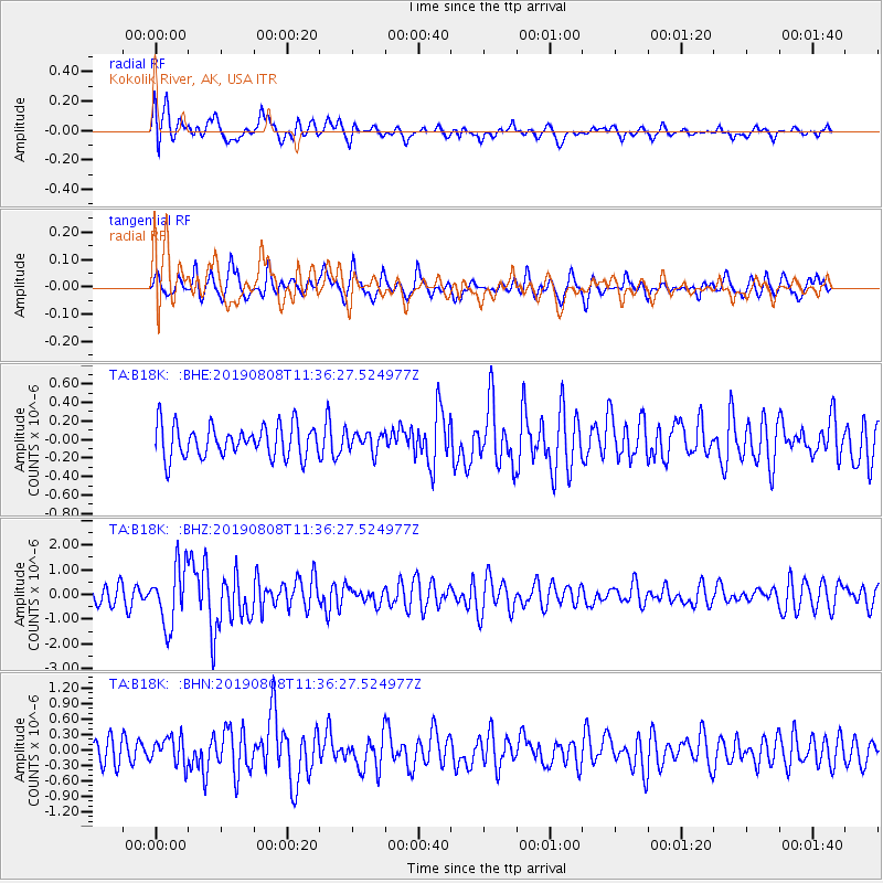
Signal To Noise
| Channel | StoN | STA | LTA |
| TA:B18K: :BHZ:20190808T11:36:27.524977Z | 4.1074076 | 1.1970019E-6 | 2.9142515E-7 |
| TA:B18K: :BHN:20190808T11:36:27.524977Z | 1.5364337 | 2.7137037E-7 | 1.7662356E-7 |
| TA:B18K: :BHE:20190808T11:36:27.524977Z | 0.5949458 | 1.03019985E-7 | 1.7315861E-7 |
| Arrivals |
| Ps | 1.8 SECOND |
| PpPs | 5.3 SECOND |
| PsPs/PpSs | 7.2 SECOND |


